

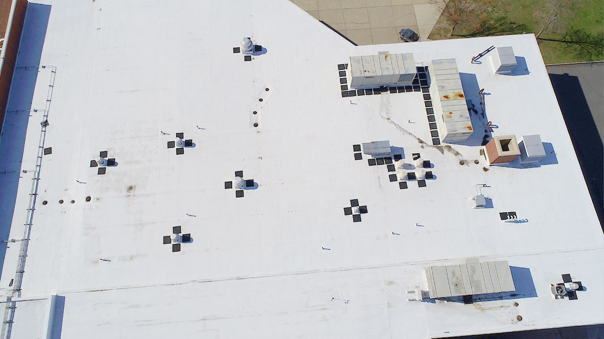
Inspecting a roof 10 times faster with drone mapping
Now, in just minutes, by using a drone and Pix4D software, you can get an online, measurable 3D model where you can pinpoint elements, measure distances, calculate areas (including walls or roof dimensions), and share the annotated model with your team and clients. From simply capturing images you can get an in-depth understanding of the space you're inspecting. Here's an example of how inspecting a roof can be more efficient with drone mapping.
Reasons for performing a roof inspection
Although you may not think of the roof over your head a lot, it does need to be maintained or used for construction from time to time. Inspecting it provides roof measurements necessary for any work on the roof. Here are some examples in which roof inspections are important, some of which aren't directly related to the roofing industry:
1. Home maintenance and construction
Before fixing a roof or checking its status, a construction company needs detailed diagrams of the roof with accurate measurements of the valleys, ridges and hips, as well as the exact position of any other elements, like chimneys or vent pipes. These roof measurements are crucial to accurately planning and implementing a building project, or fixing roof damage that can occur over time.
A roof repair company needs a detailed map in order to properly assess a damaged area for an accurate estimate for repair or re-shingle work. Prior to the affected spaces being mended, the company will need a roof inspection to understand the scale of the problem and how they can fix the house.
2. Prepare for solar panel installation
Nowadays, both homeowners and companies are realizing the value of being more sustainable and having their houses and industrial buildings powered by solar energy. Solar panel installation companies need an accurate measurement of the area of the roof in order to estimate how many solar panels would fit, the total solar panel power output, as well as the cost, time, and equipment needed for the project. Getting this information naturally requires successful roof inspections before the solar panels can be installed.
3. Home insurance and claims
The first part of the house that suffers from a natural disaster like a tornado or typhoon is the roof. As a result, homeowners need to make insurance claims on the roof damage. When this happens, it is up to the insurance inspectors to physically visit these properties, assess the damage, and calculate a fair insurance claim.
When a natural disaster happens, there are multiple homeowners that make the same insurance claims. An insurance adjuster would have to spend a lot of time climbing up each house and estimating the damage. With a drone, the inspection of several houses can be done in a single day with just a few drone flights. Not only does a drone roof inspection make the job safer, but much more efficient and accurate.
Why surveying a roof with drones is a good idea
Increase productivity and improve safety
An aerial drone roof inspection can speed up the inspection process, and reduce the risk of work accidents and damage to the client's property. It is also incredibly precise, with drone roof inspection measurements 99.4% accurate. Aside from the time and effort needed to climb a roof, lots of manual measurements and accurate photo acquisitions are required.
"Thanks to Pix4D, we don’t climb on roofs anymore and we make our measurements in 5 minutes instead of 60. Bringing better safety and higher productivity to the PV industry."
-Nicolas Vodoz, Sunergic SA
Fly and create a measurable 3D model in minutes
As drone technology advances, so do the tools for drone based solutions. To plan an aerial drone roof inspection, the drone flight planning app PIX4Dscan can create a flight plan. After capturing the imagery, the images can be uploaded to PIX4Dinspect or PIX4Dcloud to get a 3D model in minutes using our inspection software. This model can then be used for measuring distances and visually inspecting the roof.
Inspect, measure and share your projects
Navigate your 3D model, identify elements, measure distances and surfaces and share them with your team and clients.
Examine your model, add markers to pinpoint and label elements, measure and annotate lengths, heights, widths and surface areas. Your roof reporting workflow will be simpler, faster and safer for not having to manually climb up and take photos.

Your drone roof inspection will render an accurate 3D model with automated flight plans. When you share your 3D recreation, the person who receives it can explore it and visualize the annotations you added. Simple!
Pix4D's software solutions for drone-based roof inspections
PIX4Dmapper photogrammetry software
PIX4Dmapper is the leading multi-purpose photogrammetry software. It has the ability to produce survey-grade results from images or videos captured by any camera or drone, providing roof inspectors the flexibility and efficiency that they need.
Users can easily create custom processing templates for roof inspections, which allows them to provide and maintain high-quality services while reducing the total project time.
PIX4Dscan & PIX4Dinspect automate industrial inspection and asset management
PIX4Dscan and PIX4Dinspect make visual inspection easy. Use the specifically designed flight app PIX4Dscan to collect data and the processing platform PIX4Dinspect to create a digital twin which can make visual roof inspections easier and safer, as well as accessible from anywhere in the world.
Thanks to PIX4Dscan & PIX4Dinspect, the roof inspection will not only be performed faster than using traditional methods but also eliminate most of the risks associated with conventional roof inspections.
PIX4Dcloud online platform for drone mapping
PIX4Dcloud is the online powerhouse for drone mapping. It has high speed and accuracy for processing datasets and the ability to share results with clients without the need for specialist equipment or software, which helps roof inspectors elevate their efficiency and team collaboration.
It also gives users the ability to process their projects while in the field without the need for a powerful laptop. This is extremely useful for roof inspections, as multiple houses can be inspected simultaneously and the results can be immediately shared with the clients.


