Education solutions from Pix4D

Pix4D educational licenses


The leading photogrammetry software for schools, universities, and research

University of TokyoUNAM MexicoStanford UniversityUniversity of SydneyAUT UniversityEPFL university
BACKGROUND Pix4Dmapper workflow

Elevate education and academic research with photogrammetry

Demonstrate
Demonstrate
Use Pix4D’s easy-to-understand and intuitive solutions to demonstrate the principles of photogrammetry and 3D modelling.
Teach
Teach
Enhance your curriculum or design your courses with the help of our extensive knowledge base, online training materials, and tutorial videos.
Research
Research
Advance your research with Pix4D’s cutting-edge solutions in mapping and photogrammetry.

“Together with Pix4D, scientists believe that this data will fill some important knowledge gaps and provide time series and spatial resolutions previously not achievable.”

Daniel Ierodiaconou, Senior Lecturer, Deakin University Australia

“Pix4D has been a great tool to us at MTSU, and the videos from the Video Academy are spectacular”

Douglas Campbell, Unmanned Aircraft Systems Operations Manager, Middle Tennessee State University

“My team is using Pix4D to manage, mosaic, and analyze large quantities of drone imagery captured over a variety of California landscapes. We’ve been flying to image vegetation communities under drought stress; post-fire landscapes; and critical agricultural crops. Pix4D makes it easy to assemble large data cubes of high resolution imagery for high spatio-temporal imagery analysis, particularly in regard to vegetation (phenology, links with hydrology, climate change).”

Maggi Kelly, Professor and CE Specialist, UC Berkeley

“Pix4D software is a valuable photogrammetric suite which enables our students to process their own data set. They realize the complexity of the image processing chain and they feel fascinated when they get nice outputs for their projects. The quality control report is also used in this training activity and they are aware of the importance to assess the accuracy of the final product.”

Pierre-Yves Gillieron, Professor, EPFL

Empowering the leading colleges and universities with cutting edge technology

More than 2,000 institutions worldwide trust Pix4D

PIX4Dmatic

Cutting-edge photogrammetry solution for terrestrial and aerial mapping and analysis

  • Student, professor, and classroom licenses available
  • Includes all commercial software features
  • Unlimited desktop processing
  • Includes support and upgrades


Educational terms and conditions apply

Pricing
Pix4Dfields

Hybrid drone and satellite mapping software for aerial crop analysis and precision agriculture

  • Student, professor, and classroom licenses available
  • Includes all commercial software features
  • Unlimited desktop processing
  • Includes support and upgrades

Educational terms and conditions apply

Pricing
Pix4Dcloud

The online platform for ground and drone mapping, visualization, and sharing

  • Yearly professor licenses available, including credits
  • Includes all commercial software features
  • Includes support and upgrades

Educational terms and conditions apply

Pricing


PIX4Dsurvey

Create engineering-ready CAD vector files from point cloud data

  • Student, professor, and classroom licenses available
  • Includes all commercial software features
  • Includes support and upgrades

Educational terms and conditions apply

Pricing
PIX4Dmapper

Multipurpose photogrammetry solution for instructors and researchers

  • Student, professor, and classroom licenses available
  • Includes all commercial software features
  • Includes support and upgrades


Educational terms and conditions apply

Pricing
Pix4Dreact

Accurate 2D maps from aerial imagery for reliable situational awareness, processed in minutes

  • Student, professor, and classroom licenses available
  • Includes all commercial software features
  • Includes Support and Upgrades

Educational terms and conditions apply

Pricing

Professor

Single-seat license with all commercial software features

*Proof of enrollment will be verified

Classroom

25-seat license designed for classroom instruction with all commercial software features

*Proof of enrollment will be verified

Student

Single-seat short-term license designed for student learning

*Proof of enrollment will be verified

Pix4D course material for education

FREE Course material

Theory, exercises and datasets

Design your academic program and take your classes to the next level with our latest training course material.


Request course material
discount for educational institutions

Using photogrammetry in research

Thermal mapping using photogrammetry

UAS Research Poster Competition: Thermal mapping the ocean

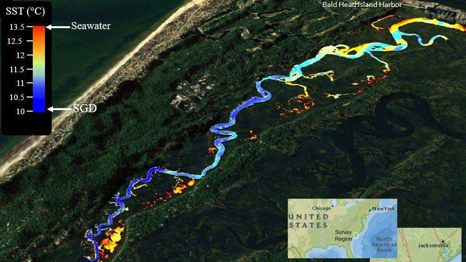
Learn how the the University of North Carolina in Wilmington addressed the ambiguity associated with groundwater discharge sources using drones and thermal mapping and won the award.


Read more >
Mapping the Kilauea volcanic eruption with drones

Using drones to map the Kilauea volcanic eruption

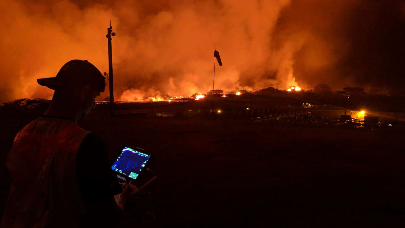
Learn how Dr Ryan Perroy from the University of Hawaii at Hilo and his team of students and staff used drones to map the lava flow and help mitigate the effects of the disaster.


Read more >
Drones helped in mapping Hawaiis volcano erruption in minutes

Mapping 3,000 meters underwater with videogrammetry

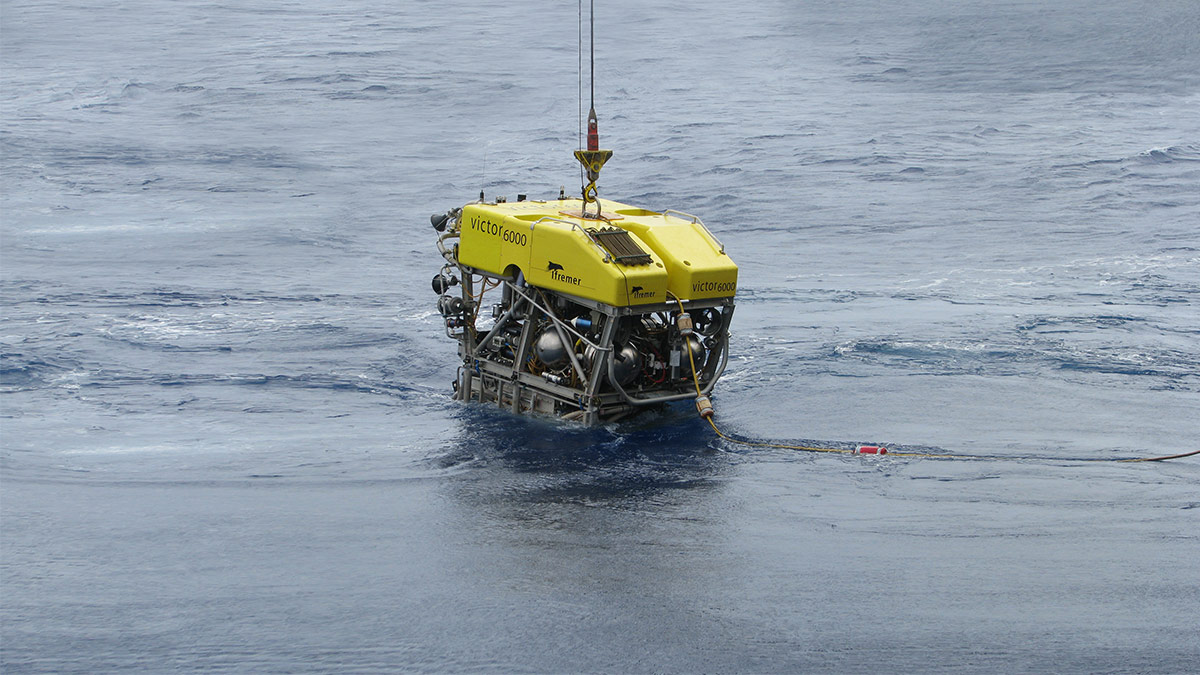
The seabed is one of the last places on earth which is relatively untouched by humans. Learn how a team from the Senckenberg Institute created a 3D model from video footage to study it.


Read more >
Read more use cases about research using photogrammetry
Pix4D Educational licenses
Teach and research the future of photogrammetry