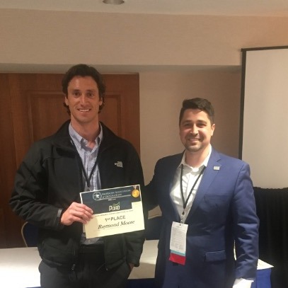
Award-winning work in mapping water temperatures
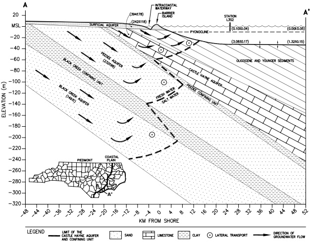
Just like rivers run to the sea, groundwater from aquifers seeps into the ocean. But as water percolates through the ground, it is exposed to nutrients, metals, and pathogens which can be carried with it, contributing to the oceans geochemical cycle and potentially disrupting a vulnerable coastal ecosystem.
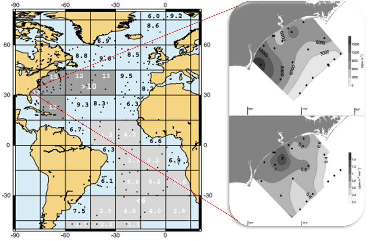
It’s a big issue, as nutrients flushed into the sea from submarine groundwater discharge (SGD) can exceed those from rivers.
“Locating sources of submarine groundwater discharge is important because it often carries pollutants, for example nutrients from sewer systems or agriculture,” explains Raymond Moore, a graduate student from the University of North Carolina, Wilmington. “However, precisely locating SGD is challenging because the distribution along the coastline is not uniform, nor is the volume of groundwater discharged.”
Moore’s research at the University of North Carolina Wilmington was designed to address the ambiguity associated with submarine groundwater discharge sources: “We combined cutting-edge unmanned aerial system thermal infrared imagery with the newest technology for continuous and autonomous SGD monitoring,” he says.
The research earned Moore and his team the first place prize for students in the UAS Research Poster Competition with the entry: “Integrating Multispectral and Unmanned Aerial Vehicle Thermal Infrared Remote Sensing with In-Situ Radon Measurements to Detect Submarine Groundwater Discharge in Onslow Bay, NC.”
The UAS Research Poster Competition, sponsored by Pix4D
Pix4D was proud to sponsor the first ever UAS Research Poster Competition at the American Association of Geographers (AAG) Annual Meeting this past April.
Both students and non-students were invited to enter. The competition was judged by Pix4D Senior Technical Trainer, Jeffrey Miller, along with Adam Matthews, Ph.D, Assistant Professor from Western Michigan University, and Anthony Cummings, Ph.D, Assistant Professor from the University of Texas at Dallas.
Pix4D also offers educational licenses for the next generation of photogrammetrists.
We spoke more to first-place winner Raymond Moore about his project and the inspiration behind it.
Project details
| Location | North Carolina, USA |
| Hardware | eBee Plus professional drone senseFly thermoMAP sensor Multiparameter water quality meter Radon detector |
| Software | Pix4Dmapper |
| Team members | Raymond Moore, Eman Ghoneim, Dave Wells, Peter Zamora Department of Earth and Ocean Sciences, University of North Carolina Wilmington |
| GSD | 14 cm |
Protecting coastal waters
“I consider myself a coastal advocate and the drive behind evaluating SGD is to develop methods for preventing the degradation of our coastal water quality,” says Moore.
“The idea for the project was born when I was an undergraduate research assistant at the University of Hawaii at Manoa under Dr. Henrietta Dulai. At UH, we implemented autonomous radon monitoring techniques in a coastal pond to investigate submarine groundwater discharge.”
In this project, Moore pushed things further: in addition to measuring radon, the team captured thermal imagery to precisely track the changes in temperature caused by groundwater discharge.
Mapping the ocean with a thermal camera
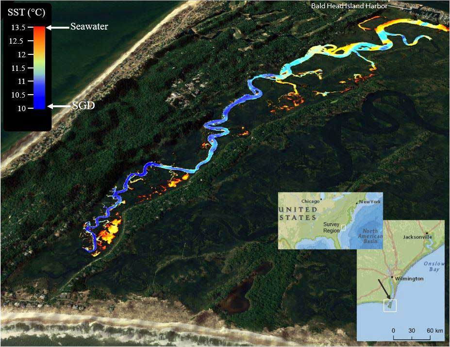
The study sites were only accessible by boat, and as maximum SGD flux occurs at low tide, the flight window was limited. Due to the drone’s battery constraints, multiple flights were required to image the entire region.
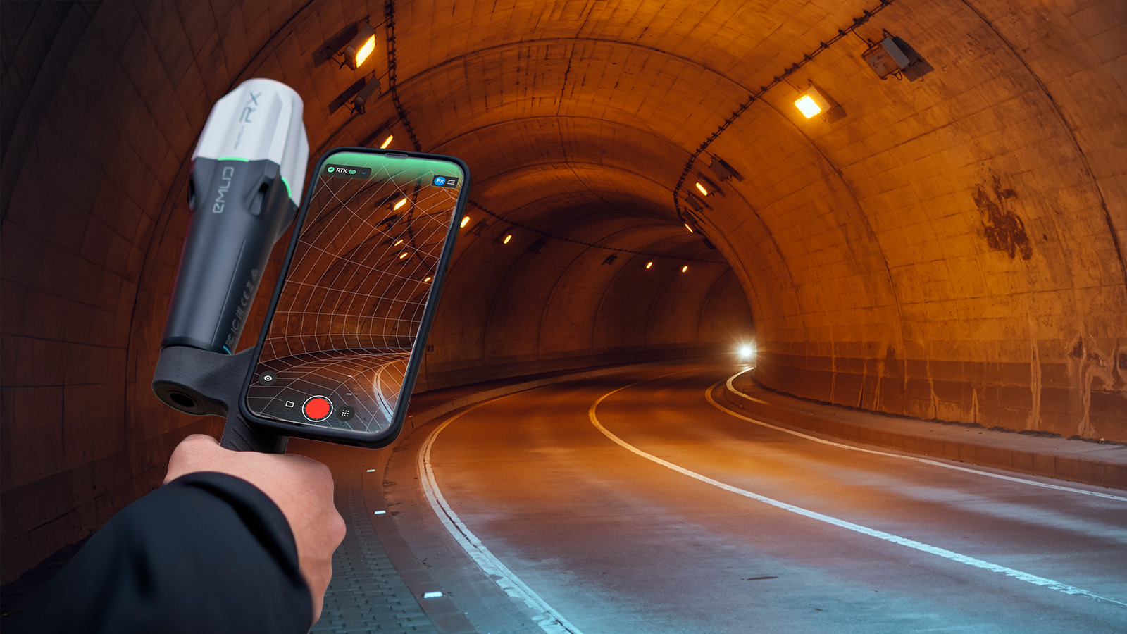
Data was collected with an eBee Plus professional drone equipped with a senseFly thermoMAP sensor capable of detecting minute changes in temperature.
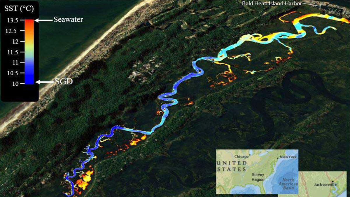
Water is difficult to reconstruct in an orthomosaic: however, the team was not focused on the water so much as the temperature.
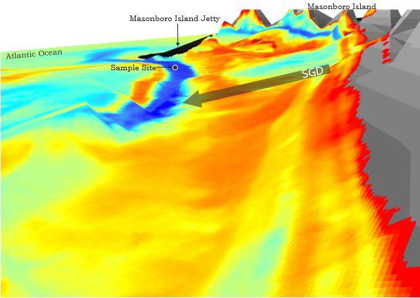
“Groundwater discharge along North Carolina’s coast is predominantly colder than ambient ocean water and, because a significant proportion of the discharge is fresh, it floats buoyantly on the ocean surface,” explains Moore. “This allows us to observe groundwater mixing characteristics with high resolution thermal imaging methods.”
To ensure accuracy, the team used ice for thermal imaging ground control points.
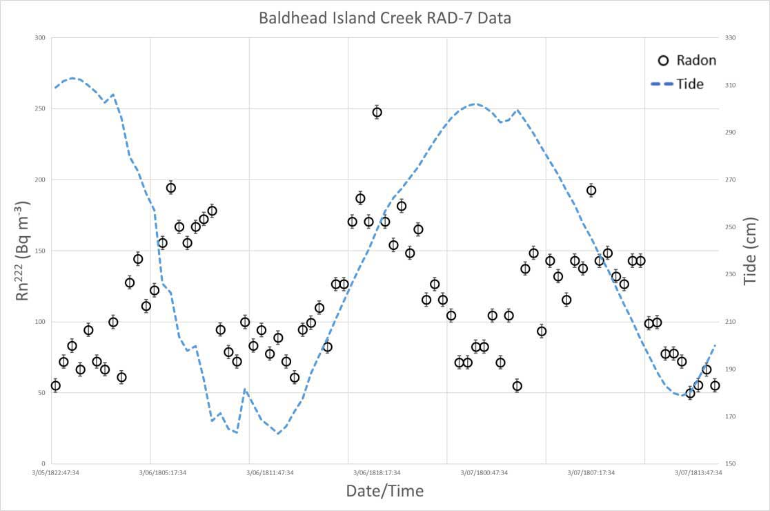
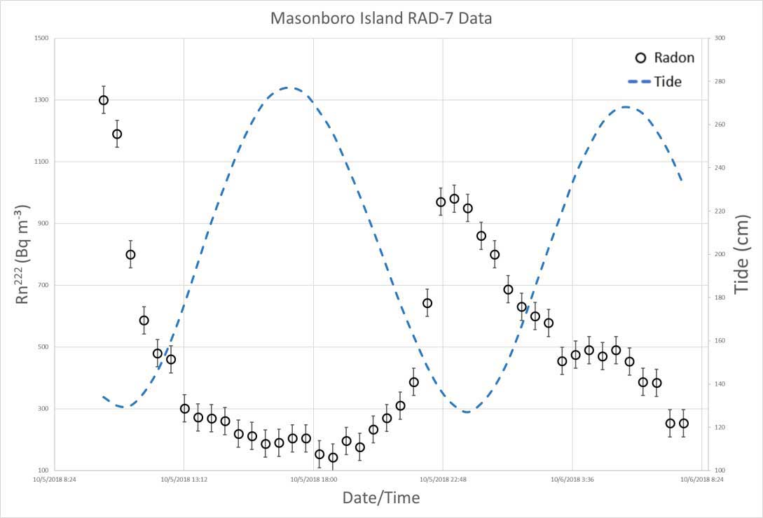
As well as aerial imagery, in-situ water conductivity, temperature, and depth, and groundwater tracer Isotopes were recorded with a multiparameter water quality meter and a radon detector. Measurements were logged continuously and autonomously on thirty-minute intervals over multiple tidal cycles.
However, not everything went smoothly.
Narrowly avoiding a drone crash
Moore recalls: “One exciting challenge we faced while piloting the eBee was a near miss with a LIDAR surveying plane.”
“We were piloting the drone on Masonboro Island a week after Hurricane Florence had passed through Wilmington. This was a standard flight that we had completed several times before. Of course, we checked the airspace to make sure there were not any conflicting flights. Everything was going exactly as planned when on the horizon we noticed a large recreational aircraft approaching at an alarmingly low elevation.”
“We took immediate evasive action to safely land the drone and avoid a crash. There is no room for error when you must make a rapid descent.”Moore continues: “The situation was intense because of this study sites location on a barrier island that is only 300 meters wide. We had two options for landing: we could either make a rapid spiral descent at the eBee’s current location or return to the take-off location for a predetermined landing with a modified approach direction. We quickly decided the second option was the call given the limited space for error that comes with flying expensive electrical equipment very close to open water!”
“Luckily the drone made a safe landing. Moments later the plane passed directly overhead well within our airspace. The sensor attached to the plane was sending off green laser beams (LIDAR) down on us. This plane was assessing the post-hurricane Florence impact on Masonboro Island.”
Processing thermal imagery in Pix4Dmapper
Safely back on land, the data was imported into Pix4Dmapper. Moore and the team created accurate orthomosaics which identified SGD plumes within the survey region.
In-situ radon, temperature, salinity, and global positioning coordinates were measured during the survey for data validation.Compared to commonly used chemical tracing techniques, using geospatial analysis of thermal data is a more cost-efficient, spatially-accurate, and time-efficient method for monitoring SGD.
Award-winning results
Prior to using unmanned aerial systems for thermal imaging, spatial and temporal ambiguity made SGD difficult to evaluate. Yet with the methodology developed by Moore and his team, SGD flux can be quantitatively evaluated. Moore notes that “There is a demand for more research supporting the connection between these variables over a variety of geologic settings.”
The innovative use of drones and Pix4Dmapper earned Moore and the team first place for students in the first ever UAS Research Poster Competition.
Moore concludes: “I would love to pursue a career where I can continue my research as an advocate for our coastal regions. It is our responsibility to protect and monitor our coastal zones by detecting, investigating and eventually mitigating any potentially threatening pollution sources.”
“I envision drone mapping as a part of my future. This project has enabled me to develop my piloting skills as well as demonstrate yet another practical utility of drone imagery.”
Pix4D would like to thank and recognize all the contest winners and participants. Click the links to download the participant posters.
Students
First Place
Raymond Moore, University of North Carolina – Wilmington
Second Place
Duncan MacIntosh, California State University – Long Beach
Third Place (tie)
Austin Bush, Auburn University
Third Place (tie)
Christina Woehrle, Oklahoma State University
Other Student Participants
Amanda Adams, West Virginia University
Jonathon Chester, Penn State University
- Influence of Software Selection on 2D and 3D Elevation Correspondence Using sUAS Structure-from-Motion and Multi-View-Stereo Photogrammetry
Sophie-Min Thomson, University of Denver
Zachary Schwab, Saginaw Valley State University
- Examining the effects of spatial resolution on the ability of UAV imagery to detect the invasive plant species Phragmites australis on the Shiawassee National Wildlife Refuge, Michigan, USA
Non-Students
First Place
Chad Freed, Widener University
Second Place
Andrew Lyons, University of California
Third Place
Scott Graves, Southern Connecticut State University
Pix4D would also like to thank the AAG for hosting the session, as well as Dr. Cummings and Mathews for their contributions. We look forward to working with the AAG in hosting another successful research poster session in 2020!
References
1: McCoy, C., Corbett, D., Cable, J., and Spruill, R., 2007, Hydrogeological characterization of southeast coastal plain aquifers and groundwater discharge to Onslow Bay, North Carolina (USA): Journal of Hydrology, v. 339, p. 159–171. Back to article
2: Moore, W.S., Krest, J., Taylor, G., Roggenstein, E., Joye, S., Lee, R., 2002, Thermal evidence of water exchange through a coastal aquifer: implications for nutrient fluxes: Geophysical Research Letters, v. 29, p. 49–51. Back to article