64% revenue increase with PIX4Dcloud Advanced
The landscape industry is falling behind in terms of technology innovations, and LandCare is one of the first companies to innovate landscape management with the help of drones and photogrammetry in combination with mobile devices. Read on to find out how PIX4Dcloud Advanced and PIX4Dcatch are helping LandCare to ”differentiate themselves from competitors and provide better services and information to their clients” (Brandon Lanier, Branch Manager at LandCare) across three separate use cases.
Laying the grounds of the future of landscape management
Evolving from measuring wheels to drones
The landscaping industry is slow to evolve with technology. Similar to others, for many years the LandCare team has walked with measuring wheels to measure their jobsites, which is time-consuming and often inaccurate. Within the last decade, they also started to use satellite images which are not always available, especially in newly built projects, as well as aircraft imagery in some cases which is costly to obtain.
But it all changed when they started using drones and PIX4Dcloud Advanced for creating maps of their projects. Lanier explains: “ Nothing can compare to what Pix4D gives us. The Pix4D solutions allow us to utilize real-time imagery and data to accurately and thoughtfully provide our customers with service programs tailored to their specific site conditions and needs''.
Utilizing drones and photogrammetry forges LandCare as one of the first innovators in the industry. “We are creating a new path in our industry with the usage of drones to collect, map, and store data”, says Brandon Lanier.

Landscape management without drones
Without drones, landscape professionals track projects either on paper or using satellite images. However, paper is easily lost and hard to keep track of, especially in big projects while satellite images are often of low quality and sometimes do not exist, particularly with new buildings. When satellite images are not an option, professionals have to go and measure the site with a measuring wheel while walking, which often leads to inaccuracies.
“With PIX4Dcloud it is all there - we fly and measure immediately, taking around an hour. Sending the proposal to clients is a matter of days which save us weeks of work compared to traditional methods”, explains Nicholas Hoxter, Account manager and Technology Innovator at LandCare.
Streamlining property enhancements with a mobile application and a photogrammetry platform
Inspecting different landscapes with a single tool
Project details
| Company | LandCare |
| Location | Virginia, USA |
| Project size | 63 acres |
| Hardware | DJI Mavic Air 2 |
| Software | PIX4Dcloud Advanced PIX4Dcatch |
| Processing time | 8 hours |
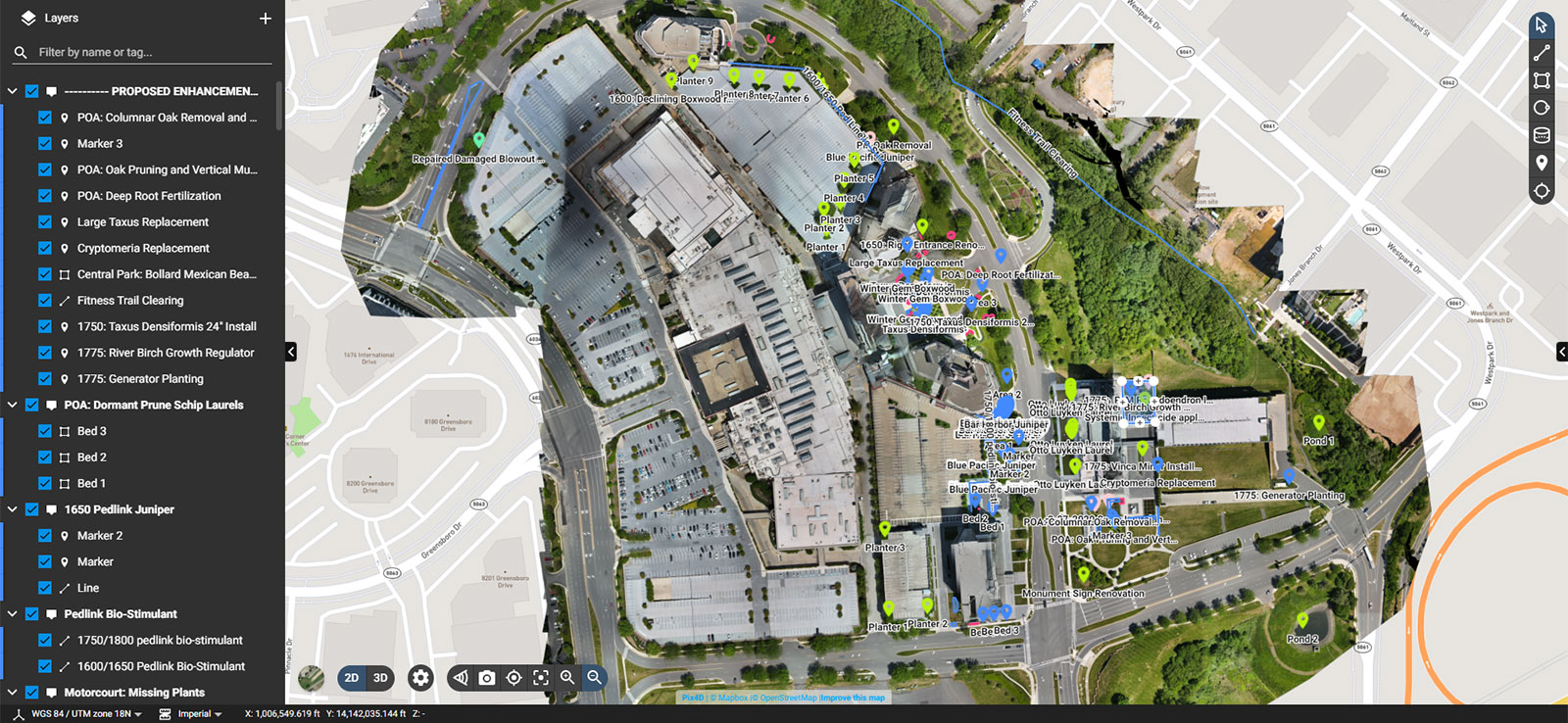
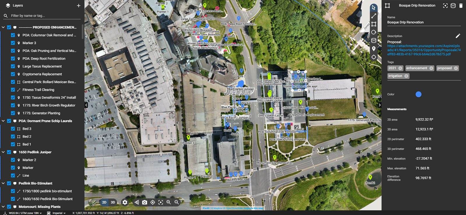
The LandCare team was contracted to manage 63 acres of property in Virginia with multiple buildings and varying landscapes. To be able to propose enhancements to the property, the team had to inspect all areas. For this purpose, they used the Virtual Inspector feature of PIX4Dcloud. For each enhancement proposal, the team made an annotation, adding a link with their proposal in the Description field plus a brief outline of what is going to happen as well as a quote.
With the help of colorful annotations, the team could differentiate approved proposals from declined ones. On PIX4Dcloud Advanced the team could also track property progress over time.
Nicholas adds: “The maps have proven really helpful with our clients and their budgets as well. What I don't sell in one year I have a greater chance of selling it in the next by helping clients visualize where they need to allocate money from their landscape budget.”
Documenting project progress
“Thanks to PIX4Dcloud Advanced we can always go back and check the colorful map to see what we did instead of looking into paperwork from previous years. All the information is there forever, and even if someone leaves the company, onboarding on the project is very easy - just log in and check the map,” explains Nicholas.
He adds: “For the client, it is also very useful to have all their information on PIX4Dcloud, as they can easily visualize where they put their money over time.”
PIX4Dcatch to the rescue
To keep monitoring the status of plants, the team had to get constant updates of the situation at the property. Typically, they would use a drone for this task. However, as the project was located in Washington DC, it was not easy to get periodic approval to fly a drone. It requires additional planning as approvals from the FAA and the local Airport are needed.
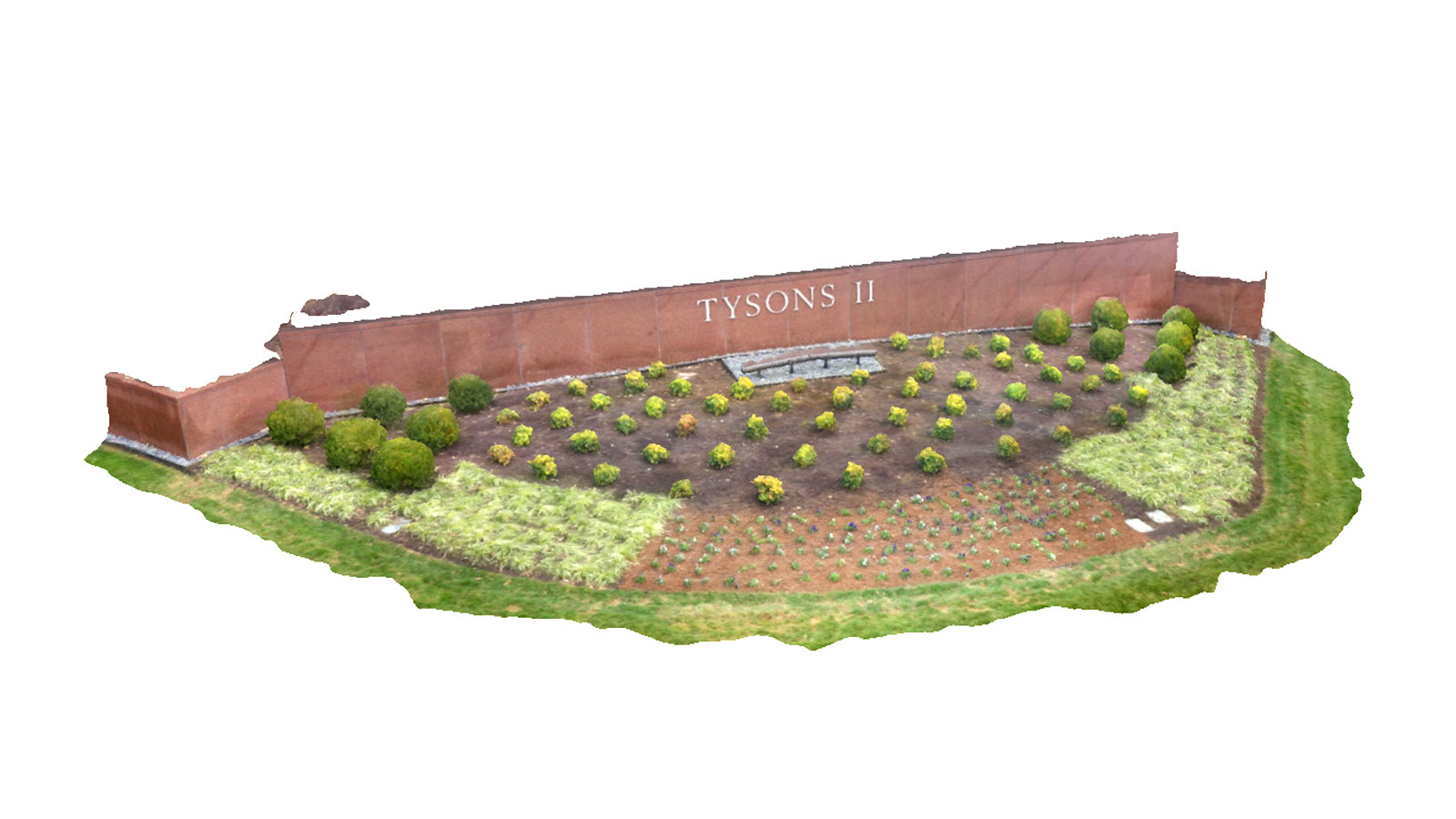
That’s why the LandCare team decided to use PIX4Dcatch to easily and quickly generate accurate 3D models of the plants. If a single plant needed to be replaced, it was captured with the mobile app and processed on PIX4Dcloud Advanced to create a new 3D model on the site map which could be compared with the timeline view. With this methodology, the information about the project was always up to date and all plants conditions properly tracked.
Property Intelligence with photogrammetry
Making sense of color annotations
Project details
| Company | LandCare |
| Location | Virginia, USA |
| Project size | 14 acres |
| Hardware | DJI Mavic Air 2 |
| Software | PIX4Dcloud Advanced |
| Processing time | 6 hours |
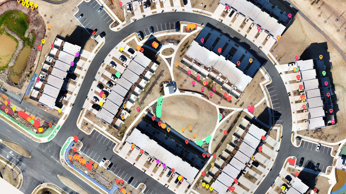
LandCare also took on a new property project in Virginia that consisted of working with a large variety of plants within its landscape. Their mission was to understand the current condition of all plants on the property and provide a detailed map containing the information captured. The property was built in 2019 and the landscape was in dire need of a professional landscape consultation.
To achieve this, the LandCare team had to walk the entire property and catalog the condition of every single plant in order to organize them into five categories corresponding to the plant's current condition: Good, Fair, Declining, Dead, and Missing. With this information compiled, LandCare was able to provide a detailed assessment of the current landscape condition followed by accurate estimates to resolve the issues uncovered. All easily displayed on a real-time high definition property map generated by PIX4Dcloud.
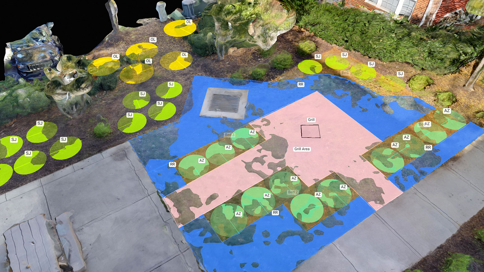
The team used a drone and PIX4Dcloud to make a 2D orthomosaic of the whole property and its vegetation, marking each plant with different colors depending on its condition - green for in good condition, yellow for fair, orange for declining, red for dead, and pink for missing. Each plant was also annotated with a brief description.
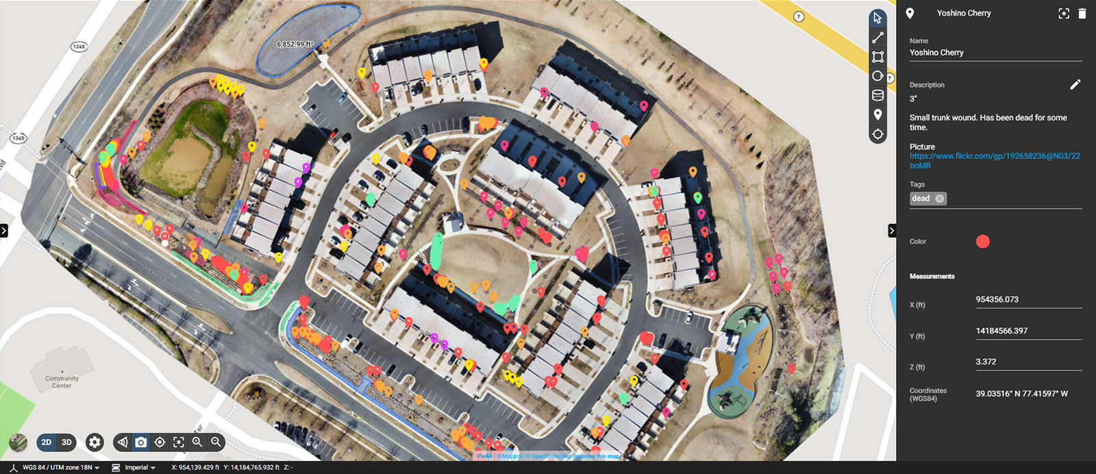
To begin the process of creating an accurate estimate for replacing the dead, declining, and missing plants, the LandCare team was using the “Export as .csv” function on PIX4Dcloud to generate a list of all plants that were captured, which they can send directly to plant nurseries for a quote on replacement plants. Additionally, as the team offers a 1-year guarantee on all plant material, the date of planting can be added to the corresponding pin and provide complete transparency of the project to the client.
“No other competitor could compete with the detailed information we could provide thanks to PIX4Dcloud. Once we replace all of these plants in the spring, all of the icons shown in the map will turn as green as the plants themselves and we will continue our property intelligence year over year to provide an unmatched service of landscape management,” adds Nicholas.
Collaboration in real-time
LandCare has been able to use PIX4Dcatch and PIX4Dcloud to share their vision with clients for potential changes, with clear design ideas and a simple way to track changes. The greatest advantage LandCare has noticed is the ability to collaborate on new design proposals with their clients in real-time and share insights on the project. That means they can make changes immediately, which is a unique experience for the customer and gives them more control over the project. The recommendations from LandCare can be seamlessly integrated with the preferences of the client without miscommunication or unnecessary meetings
64% revenue increase for eleven months
Since using PIX4Dcloud, the LandCare team has seen noticeable improvements in their productivity, being able to generate 64% increase in enhancement revenue and 200% increase in enhancement proposals compared to the previous year. Nicholas claims: “With Pix4D in the last eleven months I have proposed more than what I proposed throughout my 5 years at this position. Thanks to PIX4Dcloud I can provide more ideas to clients, bringing more opportunities for us. It’s simple - when someone calls, I do a map and send a proposal within minutes.”
One solution providing real-time imagery and data to track landscape projects
“PIX4Dcloud has allowed us to map and create a database of our sites, tracking property issues on both finished and current projects. This allows our company to not only illustrate where a customer has the greatest need on a property but to also help them track the evolution of the property, year over year. This is an even greater asset to out-of-state ownership and property management, who do not have the ability to physically inspect their sites on a regular basis”, says Brandon Lanier, Branch Manager at LandCare.
About LandCare
LandCare is a US-based provider of commercial landscape services with over 60 branches in more than 20 states. The company focuses on a variety of landscape projects including large malls, home communities, apartment complexes, retail centers, and more.