Using mobile 3D scanning to cut visits to excavation sites
Cities are getting bigger and more complex as they grow. Yet the basic issues can still grind them to a halt: broken power lines, faulty water pipes, broken sewage works. This infrastructure is key to keeping people and the city happy, healthy, and as free of disruptions as possible.
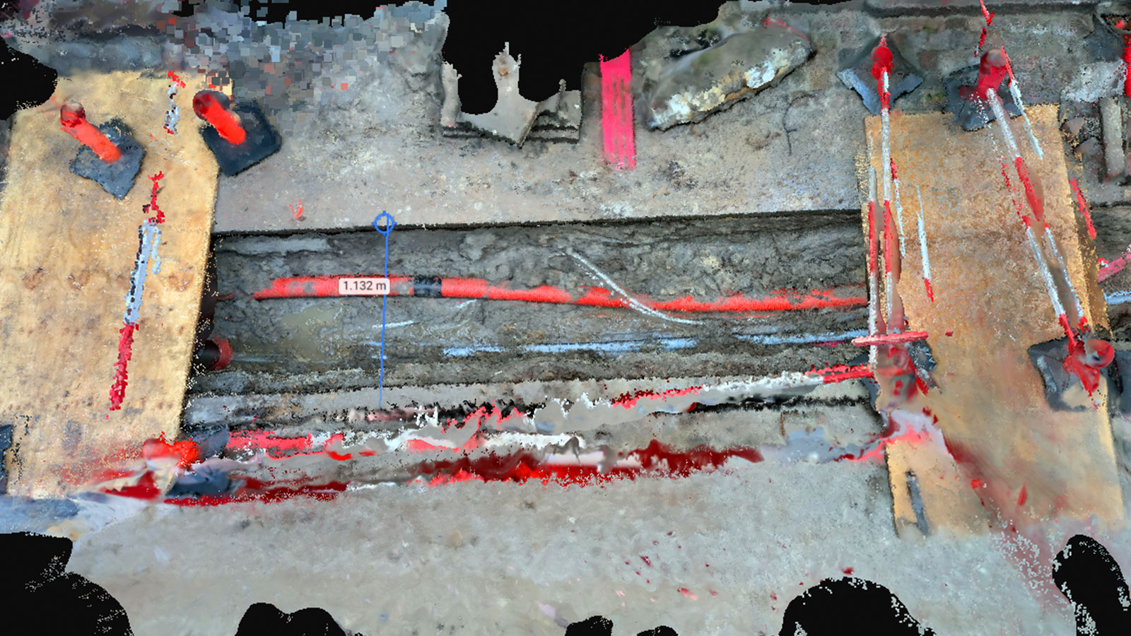
Nordkysten, based in Copenhagen, Denmark, works on construction sites as well as around the city on replacing and repairing networks of power lines and pipes. On average, they construct and refill 1,500 pits per year which are used to access these utility networks needing maintenance or inspection. Sometimes Nordkysten work on delicate power cables with 0.5 kV up to huge cables at 132 kV. These diverse arrays of cables need different levels of excavation, but still need their status and maintenance requirements reported to clients. Using PIX4Dcatch to do this empowers Nordkysten to send data about the site to clients without unnecessary site visits.
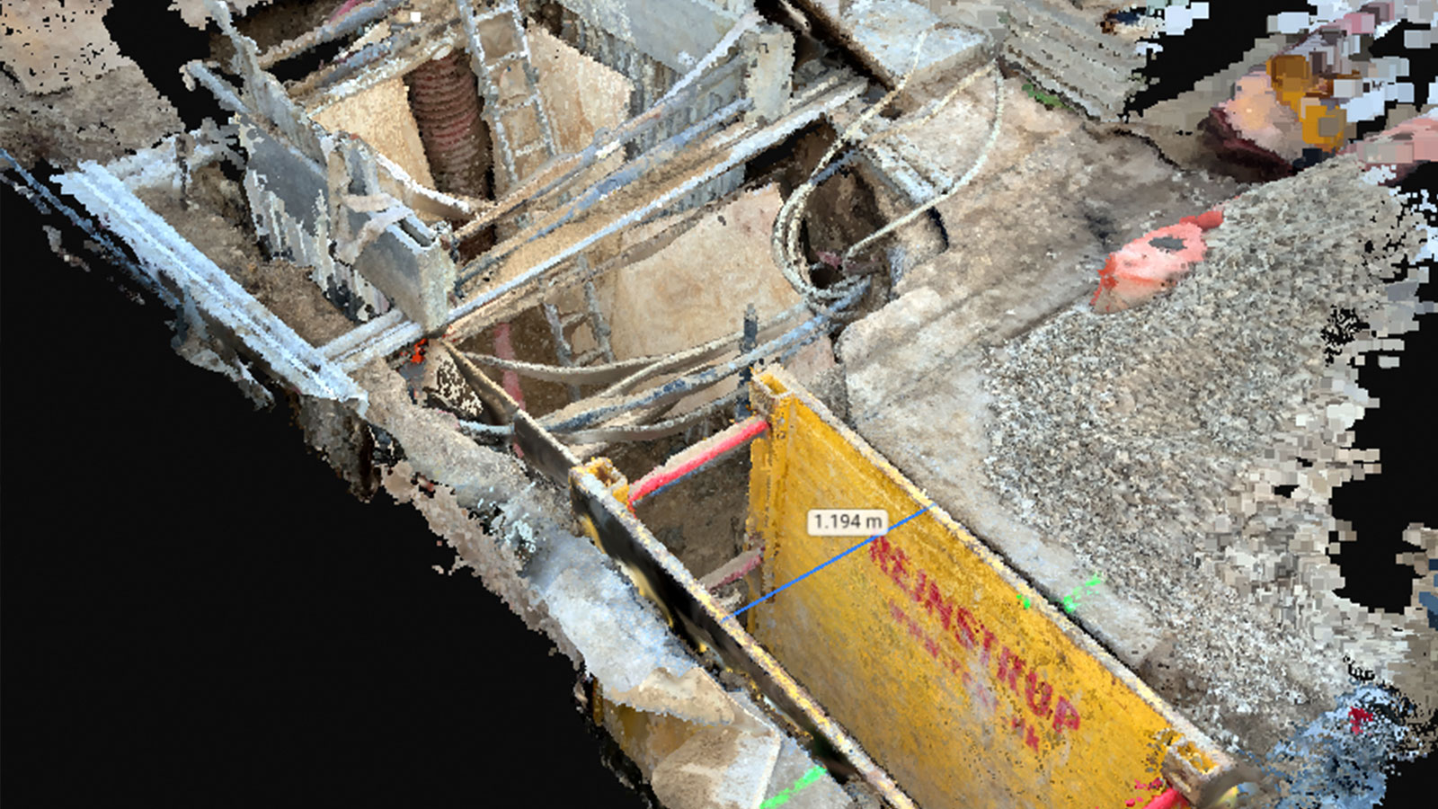
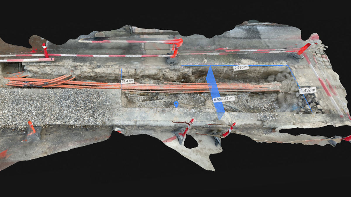
Nordkysten uses PIX4Dcatch and PIX4Dcloud to scan the pits that have been excavated to access utility networks. Working this software saves Nordkysten and their clients money and time. PIX4Dcatch provides an in-depth visual representation of the site that can be shared with clients through PIX4Dcloud. The model generated using the PIX4Dcatch and PIX4Dcloud solution is a digital twin of the actual site: stakeholders can see the exact dimensions of the pit, as well as the status of the utility being inspected and the work needed. This enables better planning, cutting costs and idle time as the fast flow of information speeds up decision making which in turn means repairs are started and completed more quickly. The software can also measure the volume of pits and ditches to plan for refilling the excavation site.
The key benefits of using PIX4Dcatch are twofold: firstly, any constructors at the jobsite can gather the data and upload it to PIX4Dcloud where it can be used for engineering and documentation. It does not require specific training for successful modeling, especially if users follow the PIX4Dcatch best practices. Secondly, stakeholders can see the scan soon after it is made, getting all of the details about the site without ever having to set foot on it. The scan provides more detail and depth than photos, enhancing its overall value.
Project details
| Location | Copenhagen, Denmark |
| User | Nordkysten |
| Total images per pitch | 300 - 1200 |
| Software | PIX4Dcatch PIX4Dcloud Advanced |
| Data collection hardware | iPad Pro, iPhone 12 Pro |
The benefits of working with photogrammetry
When Nordkysten is on-site, they want to be as efficient as possible whilst keeping their clients informed of progress. Gathering information about the site was not always straightforward when it came to getting accurate measurements quickly. However, that has changed with PIX4Dcatch and PIX4Dcloud Advanced. Firstly, PIX4Dcatch is user-friendly and can be operated by anyone in the field. The app can perform accurate 3D scans using photogrammetry together with either LiDAR technology in iOS devices or time-of-flight (ToF) sensors with Android systems. Incorporating LiDAR data with photogrammetry boosts the overall accuracy of the project by consolidating the photogrammetry data with the laser-precision of LiDAR.
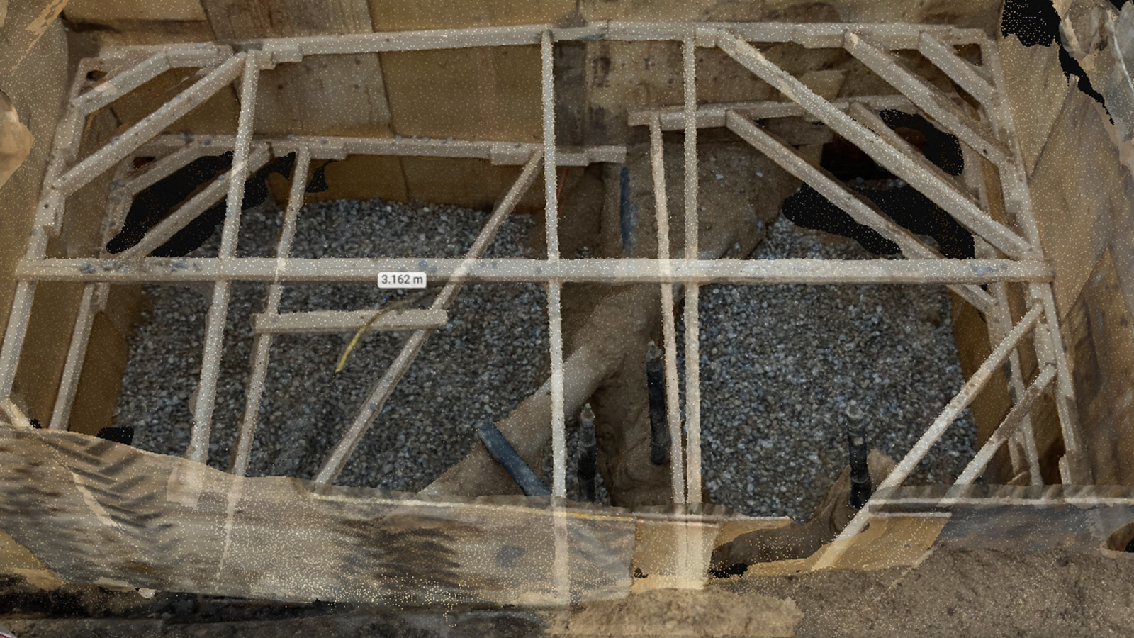
The raw data is then automatically uploaded to PIX4Dcloud, which processes the images and LiDAR data to generate a 3D model which can be shared within the company and with customers. With a variety of outputs, PIX4Dcloud enables users to measure and calculate distances and volumes on a site and use the timeline feature to compare changes over time. PIX4Dcloud can now document the exact size of an excavation with the data from PIX4Dcatch, and easily share the 3D model with clients, as well as the timeline of opening the pit, maintenance work, and refilling it.
This is especially useful for maintaining safety regulations on construction sites. Open pits and excavations are a safety hazard, as people can fall into them. Minimizing the number of people on-site minimizes the risks for accidents, but can mean it is harder to share information with stakeholders. Nordkysten works on multiple sites at a time, and may not be able to have clients visit every site without delaying progress.
PIX4Dcatch and PIX4Dcloud now offer an alternative: an accurate 3D model available online, that not only is useful for the stakeholder but also provides measurements and data that Nordkysten can use to make their own work easier, such as refilling an excavation. They can share the data before the pit is refilled, getting confirmation from the stakeholder that everything is up-to-standard without the stakeholder ever having to visit the site.
Workflow for PIX4Dcatch
- Download software/open app
- Capture data
- Upload to PIX4Dcloud
- Process on PIX4Dcloud
Photogrammetry in construction
Nordkysten is a growing company, with 350 employees and 100 subcontractors. Organization is the key to their success, and the combined power of PIX4Dcatch and PIX4Dcloud is streamlining their workflow, giving their clients more information, and keeping the pit sites safe.
"I discovered PIX4Dcatch via a blog where people were discussing the LiDAR capabilities of new iPhones and iPads. We are thrilled to work with Pix4D and are seeing huge benefits in using it for measuring volumes, documentation and for data sharing with clients." - Frank Schou Kruse
Photogrammetry is making a huge difference in the construction industry by keeping workers in touch with stakeholders without slowing workflows or requiring unnecessary visits to the jobsite. Combining RTK accuracy with handheld 3D scanning with phones, unlocks new potential in mobile terrestrial modeling. PIX4Dcloud and PIX4Dcatch are bringing precise, digital versions of reality to the offices of constructors around the world, without anyone having to move.