
PIX4Dsurvey 1.22: volume reports, tin wrapping, and more!
PIX4Dsurvey 1.22 is here! The final release of 2021 comes with new control options for creating (or extracting) contour lines, easy-to-share volume reports, improved TIN wrapping, object detection, and two new languages! Some of these features are adding onto already existing functionalities - such as the Smart Grid gaining a low-pass grid option to improve LiDAR compatibility - to the brand new features, like the pdf volume report that includes an inventory of measurements. Combined with the two new languages - Chinese and French - there’s loads to explore. Find out what is new in PIX4Dsurvey 1.22.
Control over creating contour lines
Professionals use PIX4Dsurvey to get more out of their point clouds, taking it from a large point cloud to a CAD-ready file. When it comes to analyzing terrain, PIX4Dsurvey provides users with the tools to do this with high degrees of accuracy. Now, with updates to contour line control and measurement, this is better than ever.
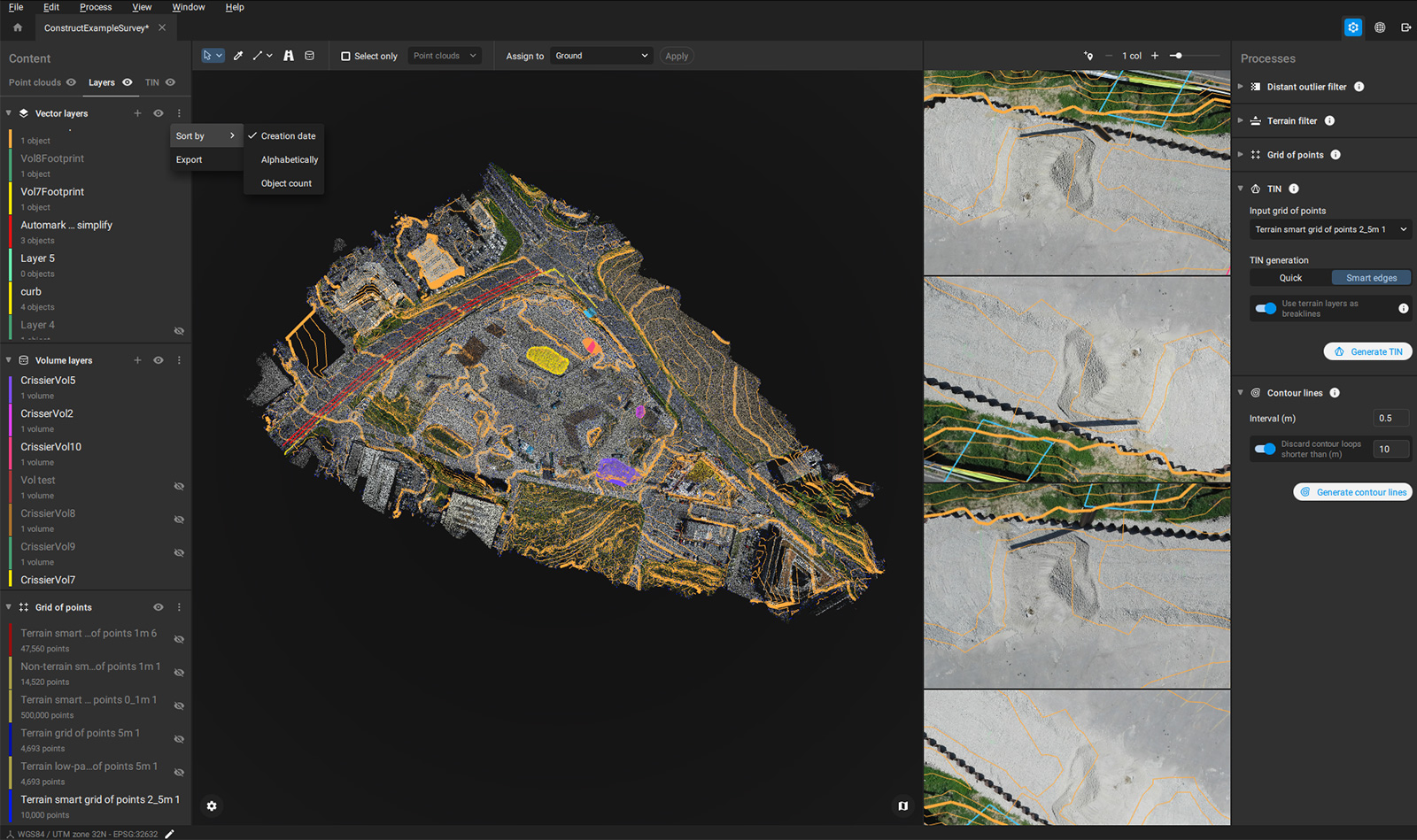
Our new contour lines have short loop control and can be displayed and exported. When combined with the new low pass grid option, it enables better LiDAR compatibility. This means that if users are using a LiDAR point cloud (or a fused LiDAR and photogrammetry point cloud), they can still get the most out of the data by picking vertically where the grid points should be placed. This data can then be exported to share with other project stakeholders, allowing for smoother overall workflows.
Volume reports you can share
The volume measurement feature was introduced in PIX4Dsurvey 1.18 in September 2021. Now, volume measurements can be compiled in a detailed report that can be exported as a pdf. This pdf includes images of the site and each measured object and measurements as well as an inventory that can be used as a comprehensive database for stockpiles or other objects on a site. This graphical report is a first for Pix4D and will provide valuable insights to you and your clients in just a few clicks.
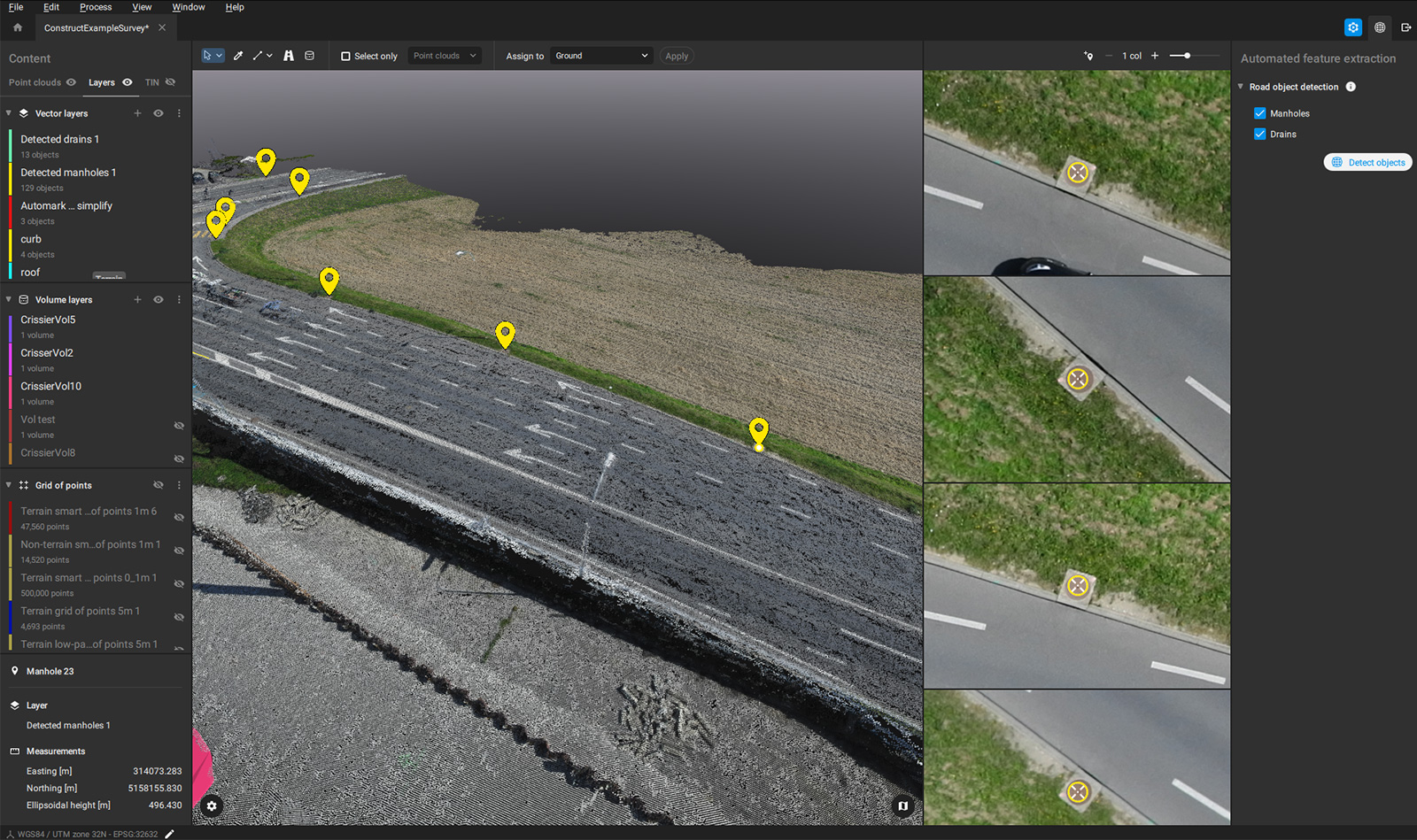
TIN wrapping and object detection
The TIN is one of PIX4Dsurvey’s most popular features as it is a professional tool. Now, it’s better than ever. The TIN now has improved wrapping to enable better edges in the TIN for a cleaner overall look. This reduces the number of long contours at the edges of your project (side benefit- fewer and more usable contour lines!).
At the same time, PIX4Dsurvey now has object detection to find manholes and drains all across the site. By using the images to search, objects that might not be very visible in point, perhaps due to resolution, shade, or vehicles in motion can still be found. It's a great complement to a pre-site survey.
Technical details and new languages!
PIX4Dsurvey is used all over the world - and that’s why we’re adding more languages to the software! Now, it is available in French and Chinese - it is already provided in English, Spanish, and Japanese.
There is also better integration with PIX4Dmapper, including an “open in PIX4Dsurvey” button in PIX4Dmapper for native movement between products. PIX4Dsurvey can also read PIX4Dmapper point clouds in p4b format, so it is not necessary to use a .las folder to export from PIX4Dmapper to PIX4Dsurvey.
The PIX4Dsurvey is always hard at work adding new features and options to our software. If you want to learn more about the products or talk to our team, make sure you’re part of the Pix4D Community.


