PIX4Dmatic & PIX4Dsurvey 1.51: clipping box and more!
PIX4Dmatic 1.51
Unveiling new heights in drone and terrestrial mapping capabilities, PIX4Dmatic's latest release brings you a suite of game-changing features. Now you can edit point clouds directly in PIX4Dmatic, unlock an advanced 3D viewing experience with the new clipping box feature, and dive deeper into camera data with our new camera externals and internals editor. Enhance your projects with the introduction of vector layers and layer templates and export your data in the versatile .XYZ format directly exporting GCPs, which offers you increased workflow flexibility. We also have algorithm improvements for better calibration and a faster DSM generation (2x faster)! Read on to explore these groundbreaking updates.
PIX4Dsurvey 1.51
Streamlining your survey and mapping projects just got easier with the latest updates to PIX4Dsurvey. With PIX4Dsurvey 1.51, we introduce layer templates for quick organization and seamless transition of vectored data across projects. Our newest release also brings a more intuitive user interface, optional geometry descriptions, and advanced manual registration options for aligning point cloud sub-projects to your master projects.
Point cloud editing in PIX4Dmatic
Point cloud editing is now an integral part of PIX4Dmatic. This advanced feature allows you to reduce noise and improve the overall quality of your point cloud. By doing so, you not only enhance the quality of the point cloud itself but also set the stage for generating superior meshes, DSMs, and orthomosaics, thereby optimizing your entire data analysis pipeline.
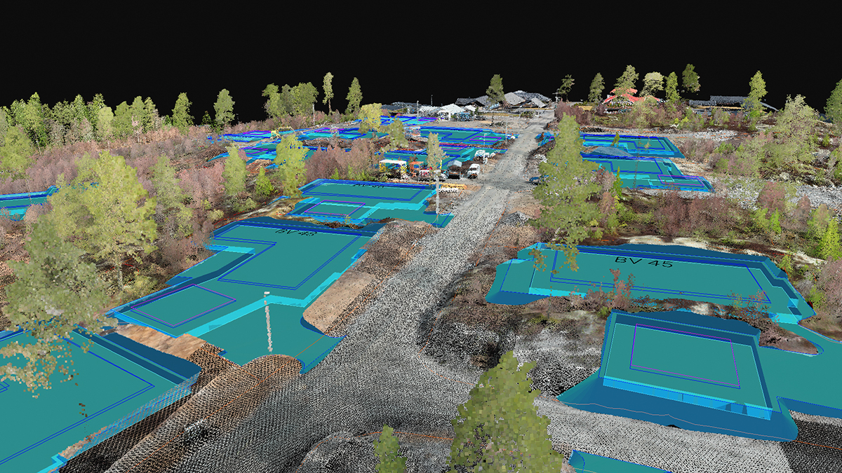
Clipping box in 3D viewer
The clipping box feature in the 3D viewer significantly enhances point cloud editing. By enclosing a specific area within a 3D box, you simplify the task of selecting points within that region. This targeted approach allows you to edit points more precisely, eliminating the risk of inadvertently selecting background elements.
Camera externals new table and camera internals editor
Camera externals table
Take control over your project's calibration parameters with our newly enhanced camera externals table and camera internals editor. These upgrades enable you to critically assess input quality, such as identifying which images have RTK accuracies, while giving you the ability to fine-tune each image.
Camera internals editor
Expand your options with our camera internals editor by saving your own camera models. This opens the door to an even broader range of camera compatibility, ensuring that the software adapts to your needs rather than the other way around.
Layers in PIX4Dmatic and layer templates in PIX4Dmatic & PIX4Dsurvey
Organize complex projects seamlessly with the introduction of vector layers in PIX4Dmatic and layer templates in both PIX4Dmatic and PIX4Dsurvey. This feature allows you to create and save unique layers for various types of vectored data (e.g., water pipes, gas pipelines, fiber optics) and effortlessly transfer them between PIX4Dmatic and PIX4Dsurvey. Coupled with layer templates, this functionality not only streamlines your project management but also accelerates your workflow by enabling you to apply your predefined settings across both platforms for future projects.
Export GCPs, new geoids, default CRS, .XYZ export, ellipsoids, and a new language!
We haven't stopped there. With this release, we are also expanding our geoid models, now offering:
- Taiwanese geoid model TWGEOID2018h (vCRS: EPSG:8904)
- Latvian geoid model LV14 (EPSG:4661+7700) Latvia 2000 height
- Finnish geoid models: FIN2000 (EPSG:4258+5717) N60 height and FIN2005N00 (EPSG:4258+3900) N2000 height
To enhance your workflow flexibility, we've added several new features to PIX4Dmatic. You can now export Ground Control Points (GCPs) directly, choose your default Coordinate Reference System (CRS), and view ellipsoids for input camera accuracies in the 3D viewer. These ellipsoids provide a visual representation of your camera's positional accuracy, allowing you to assess the quality of your input data and make necessary adjustments to your processing settings. As a valuable addition, you now have the option to export point clouds in the .XYZ file format, facilitating seamless integration with industry-specific software like Virtual CRASH and Map360 for professionals in accident reconstruction and forensic analysis.
To make PIX4Dmatic accessible to our global user base, we're also introducing Turkish as a new language, expanding our already diverse language options.
Want to learn more? Check our online and onsite workshops. We also have the brand new PIX4Dmatic Essentials online course and the Collision Reconstruction with PIX4Dmatic online course, ideal for public safety professionals. Download PIX4Dmatic now and try all the new improvements and functionalities!