
Aerial mapping of coastal ecosystems for restoration
Restoring and conserving a delicate ecosystem is a challenging task that requires long term monitoring and care. Returning to the designated sites at frequent intervals and collecting data helps conservation teams spot problems early on and implement solutions. This is why Project Seagrass is using PIX4Dfields to monitor UK seagrasses.
Project Seagrass is a charitable effort working in the UK to restore and protect seagrass meadows around the coast. They aim to monitor the growth of natural and restorative crop and are using specialized agricultural mapping software to achieve this. The first Seagrass Ocean Rescue project was across 2 hectares off the coast of Dale in West Wales. This initiative aims to work with local communities alongside conservation efforts which they hope will rejuvenate both fisheries and biodiversity.
Benefits of seagrass restoration
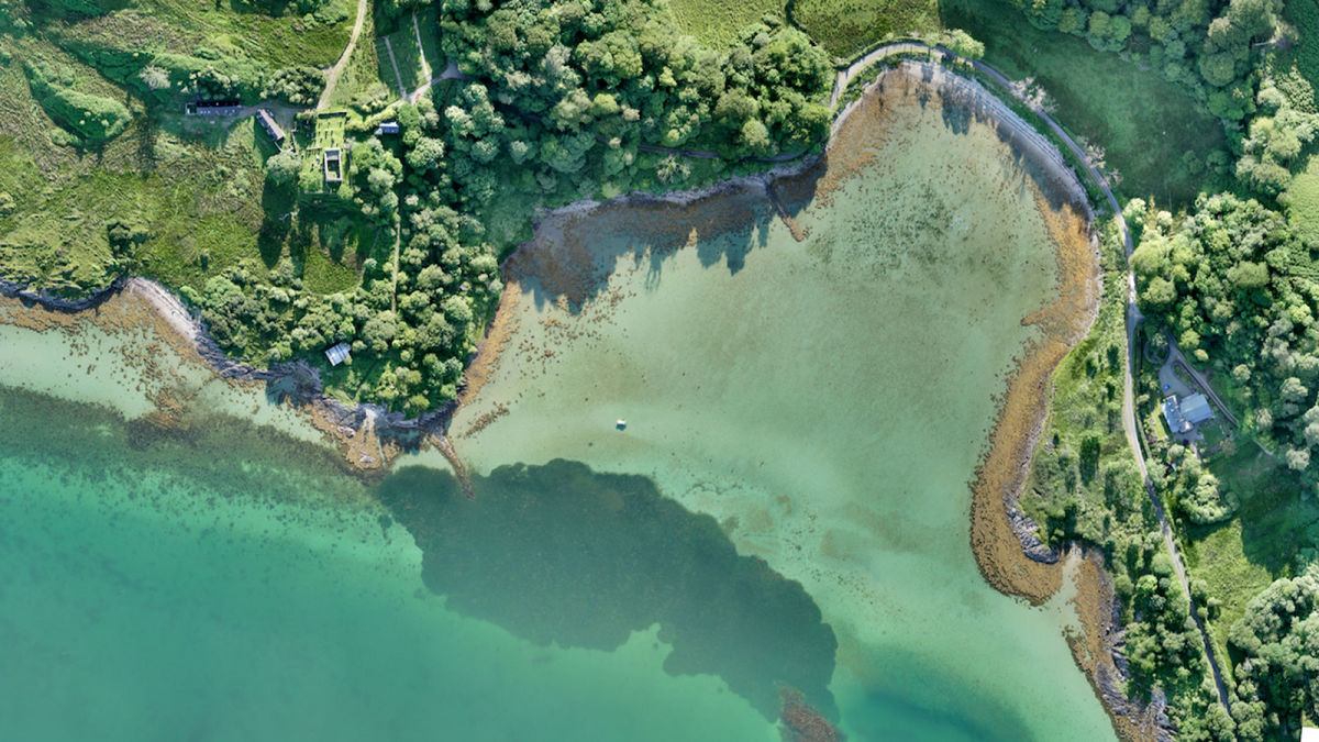
Seagrass meadows are a special coastal habitat. It grows at depths of up to 10 meters in the UK. Most of the plants monitored by this project grow in the 0 to 6 meters range. They provide a home to oceanic creatures and a natural storm defense, helping stabilise the seafloor. Monitoring coastal ecosystems like kelp forests, seagrass meadows, and mangroves with drones allows for detailed analysis whilst saving time.
It is estimated that over 90% of seagrass in the UK has been lost in the last 100 years. This is a threat to biodiversity as it provides a rich, 3-dimensional ecosystem that shelters marine life and creates a safe space for juvenile fish species such as cod. These habitats are a Priority Marine Feature (PMF) in the UK, as well as listed as a threatened and declining habitat by OSPAR. There are 26 known seagrass locations in Scotland and they are protected as part of Marine Protection Areas. By using PIX4Dfields, Project Seagrass can monitor the plant health from above and develop comparative data sets year on year which can better support the restoration process.
Project details
| Location | Dale, UK |
| User | Project Seagrass |
| Software | PIX4Dfields |
| Hardware | WingtraOne |
| Area surveyed | 2 hectares |
| Images captured | 824 |
| Processing hardware | MacBook Pro 2019 (Intel CPU) |
| Flight time | 25 minutes |
Coastal drone mapping in the UK
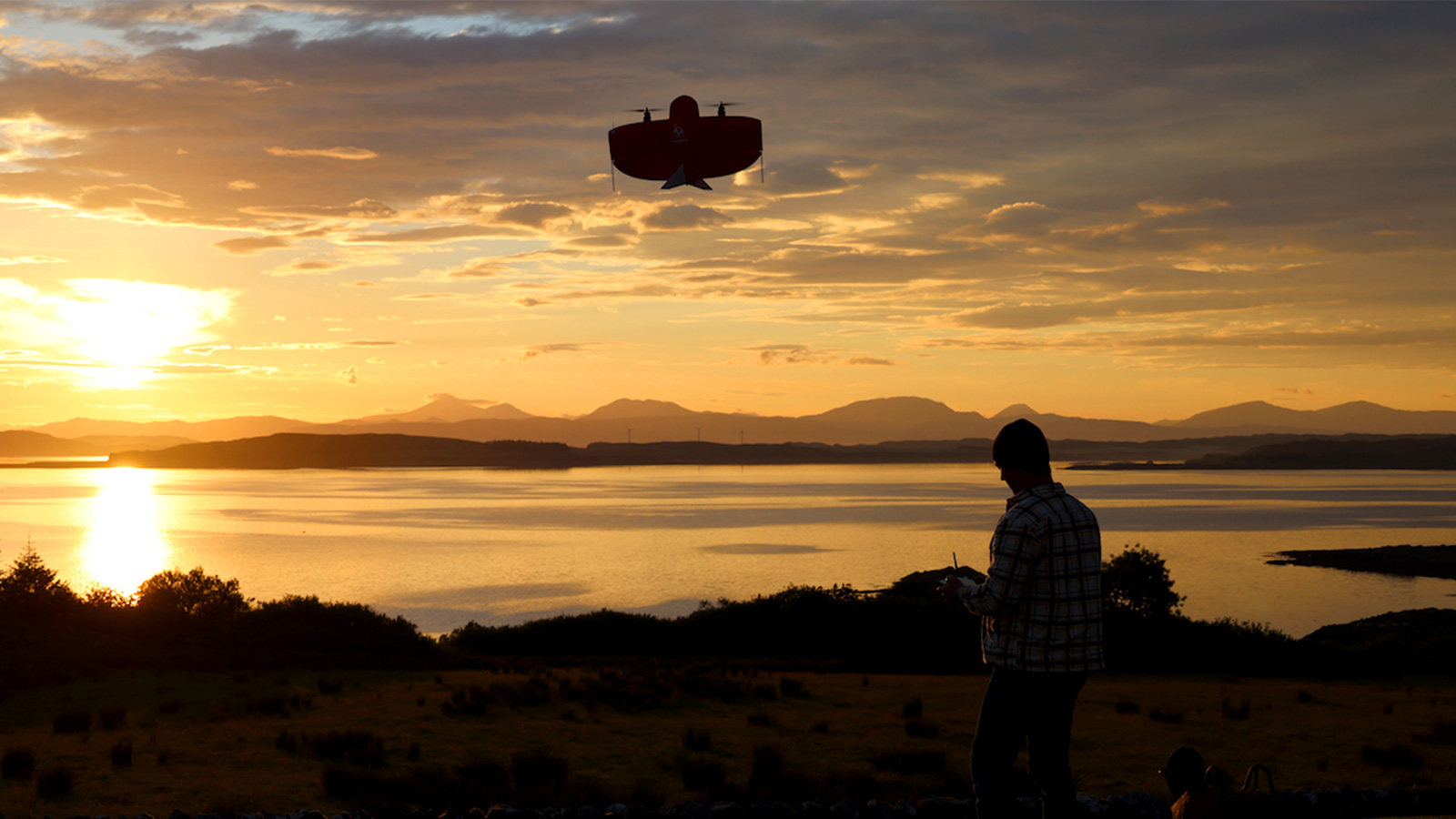
The seagrass being monitored with the Wingtra drone would have originally been surveyed using snorkelers and divers, and then a quadcopter drone. Both of these efforts rendered some results but the manual inspections with divers were labor intensive and time-consuming and the maps with multirotor drones were slow and covered considerably smaller areas. This also meant more flights were required which resulted in more time in the field. Due to the large area covered by some meadows, the team decided to invest in something more powerful, opting for the WingtraOne by Swiss drone manufacturers, Wingtra. The WingtraOne is a vertical take-off (VTOL) drone that can survey large areas with high quality image capture and results. The team can map the area at low tide to mitigate the impact of reflections from the water which can distort photos taken with the drone’s camera.

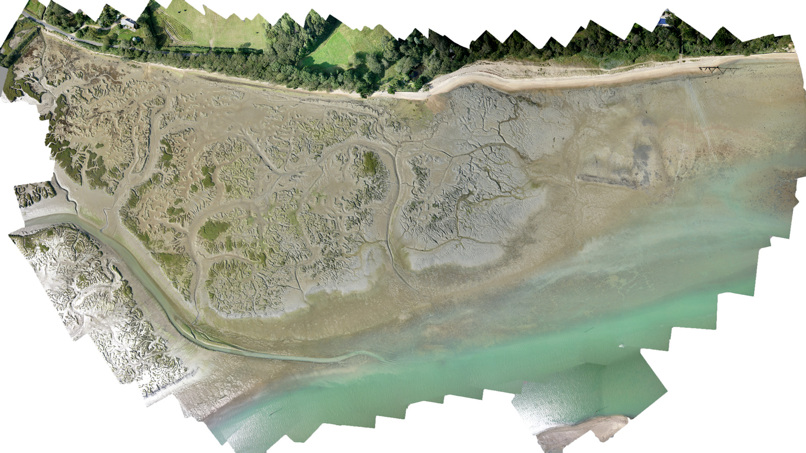
PIX4Dfields can generate orthomosaics that can then be used for GIS modeling. PIX4Dfields is a specialized mapping software for agriculture that can use RGB and multispectral imagery to generate maps that indicate plant health and surface elevation. It works offline and in the field, producing useful outputs such as orthomosaics - 2D maps that can be used to measure distances and areas. The orthomosaics created with PIX4Dfields are shared with project stakeholders to measure the progress of seagrass restoration and for publicity.
The WingtraOne offers more opportunities for surveying larger distances thanks to having a flight time of an hour, enabling greater data collection. The team can now cover several hectares in minutes, which improves the efficiency of the surveys and is useful for repeat visits to the replanting sites. In order to fall in line with UK drone laws, the pilot of the WingtraOne must hold a flyer ID and the updated GVC qualification as well as be aware of local air traffic regulations to ensure a safe flight.
Mapping the coast with drones
As seagrass is such a critical plant, monitoring the growth is important. Being able to do coastal mapping with drones means that Project Seagrass can help study this fragile ecosystem from a new perspective and will allow the team to track growth, share data, and broadcast information about their work.
“Thanks to the processing capacity of PIX4Dfields we were able to stitch together hundreds of images in virtually no time so that we can get a better understanding of the seagrass meadows!” - Eve Uncles, Project Seagrass
Ocean rewilding is a critical part of the fight in the climate emergency because these habitats are not just hubs for biodiversity but carbon sinks and the basis of livelihoods for local communities. This type of conscientious replanting, or responsible reforestation, is in practice worldwide. Project Seagrass is currently also working on sites in Scotland, Wales, and England with two Wingtra drones. As they continue with their restoration work, they hope to see improvements in the coastal health of the British Isles. This project strives to support the Sustainable Development Goals and is partnered with the UN Decade on Ecosystem Restoration and the UN Decade of Ocean Science for Sustainable Development. This is not the first instance of photogrammetry and drones being used for coastal mapping. It is a growing area of drone mapping as the ever-improving software available can provide environmental insights and on-the-ground access to areas that were previously difficult to reach.


