
Eco-friendly farms: insects and site-specific applications
The ecological importance of insects cannot be underestimated. It is therefore necessary to preserve insect habitats by reducing light pollution and reducing the use of insect-harming chemicals in the environment. Various laws and regulations have been passed to address this issue, such as the Fertilizer Ordinance and the Insect Protection Act. Insect protection is primarily not a legal problem, of course, but above all a practical issue. It raises several questions, such as:
How can insect protection be implemented in practice? How can drones and remote sensing help with insect protection?
Precision agriculture technology
What technology can you use to help with insect protection? There are lots of options, although some people are put off by the upfront cost. The biggest cost factor is usually the technology for site-specific applications, i.e. a field sprayer with task controller, which works better with section control or even single nozzle control.
Inexpensive photo drones cost around 700 EUR from the electronics market, and there are lots of choices. For example the Parrot Anafi or the DJI Phantom 4 are both well suited for use in agriculture. Although it may seem costly at first, the prolonged use of this hardware combined with the right software can bring a good return on investment. The hardware can help spot issues and measure field boundaries so that treatments can be applied to fields as precisely as possible without causing damage to the nearby ecosystems.
Insightful maps and data accuracy
As proof of how this technology can work, we are sharing an example of using a drone with a concrete data set from a wheat field near Prötzen in Brandenburg, Germany. The field was flown at an altitude of 100 m with a drone fitted with a multispectral camera.
The orthomosaics and index maps were calculated from the aerial photographs with PIX4Dfields. The accuracy of these maps depends on how the aerial photographs were collected. There are principally two ways to ensure accuracy. The first is with standard GNSS systems (usually a combination of GPS, Glonass, Galileo and Beidou is used) allowing accuracies in practice from 0.5 m to 3 m. Accuracies of up to 1-2 cm can be achieved by correcting interference of the GNSS with an RTK signal. RTK drones are significantly more expensive than drones without RTK support, but they allow for smoother integration in terms of accuracy between tractor guidance systems and application maps made from drone remote sensing.
The second option is during post processing of the maps. Using ground control points or GIS tools can help achieve higher accuracy, which will be described in another post on this blog.
Marking the area for field application
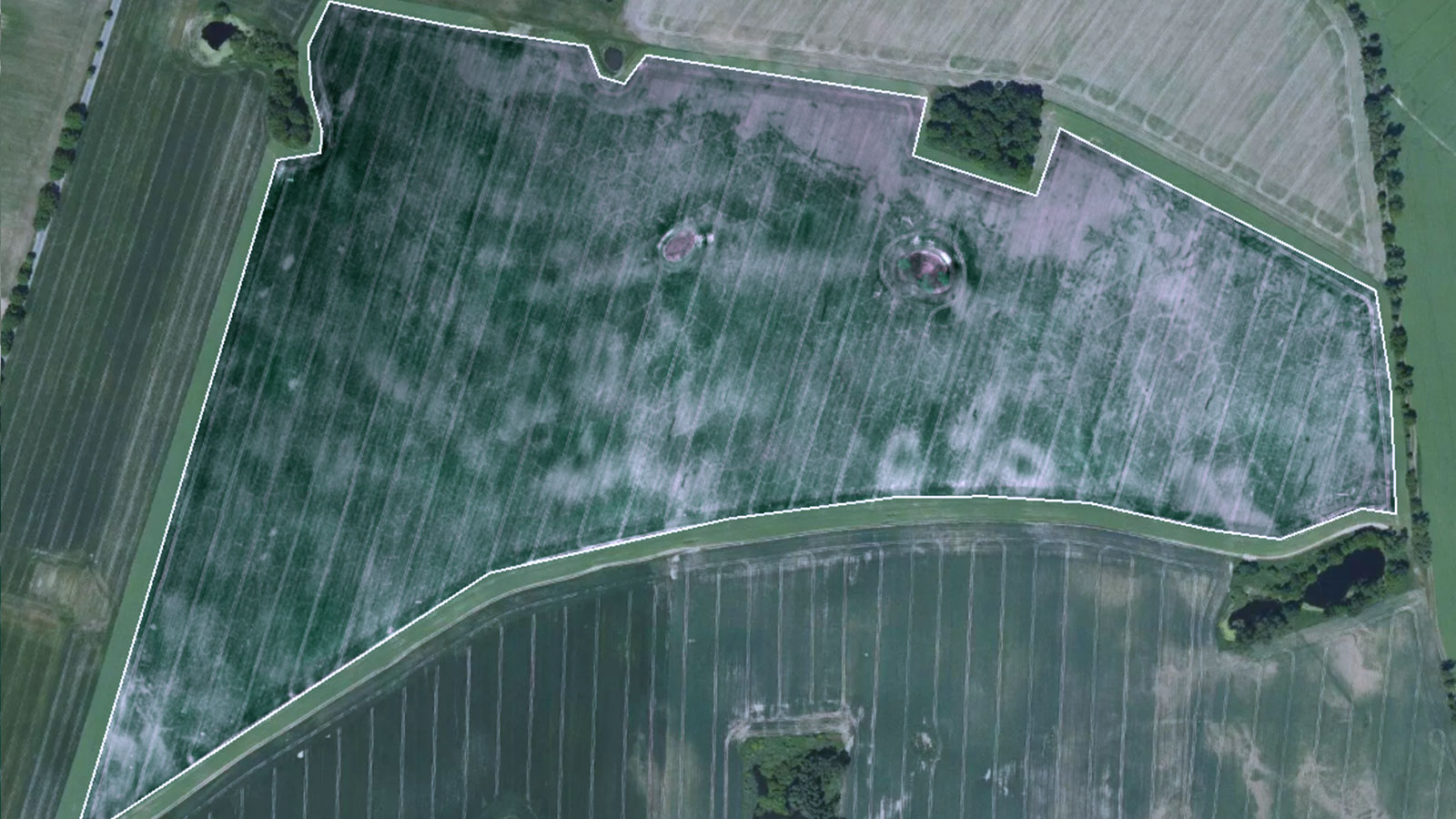
Two things stand out in our wheat field: firstly, the plant growth is clearly inhomogeneous. Secondly, there are former ponds here that can still be recognized as water areas on earlier satellite images. They have probably dried up due to climate change, as can be observed in many other places in Brandenburg. Nevertheless, these places and also the roadsides are important insect habitats, which we want to protect with a 10 m wide space away from field application of treatments.
As a first step in this process, we mark the area of the field in the orthomosaic that is eligible for the field application. We will draw this area as the boundary. Now there are two ways to mark the area for field application. One way is to edit a field boundary - it may already exist digitally - in a GIS tool to mark protected areas appropriately and subtract them from the field boundary. This data can then be imported into PIX4Dfields as a shapefile or GeoJSON.
Alternatively, it is also possible to draw in the application area in PIX4Dfields. Here, the field boundary can be described with several partial areas as a so-called multipolygon. Distance markers help ensure better orientation.
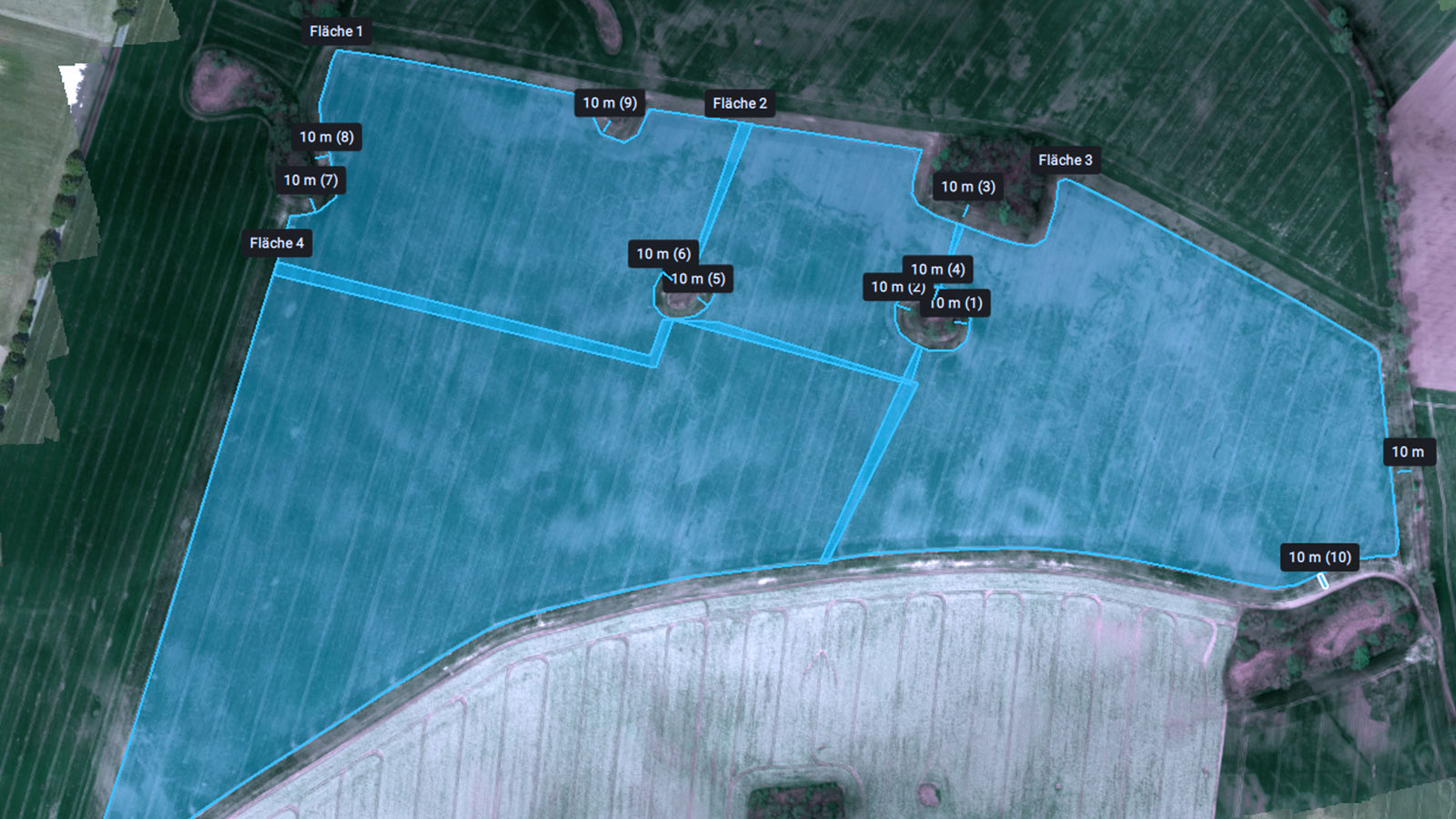
After this, users can set this multipolygon as a field boundary. To do this, a user will export the multipolygon and import it as a field boundary. With the help of the field boundary, the orthomosaic can now be trimmed accordingly. As a result, the insect protection areas are excluded from the planning of the field application.
Index maps for site-specific growth differences
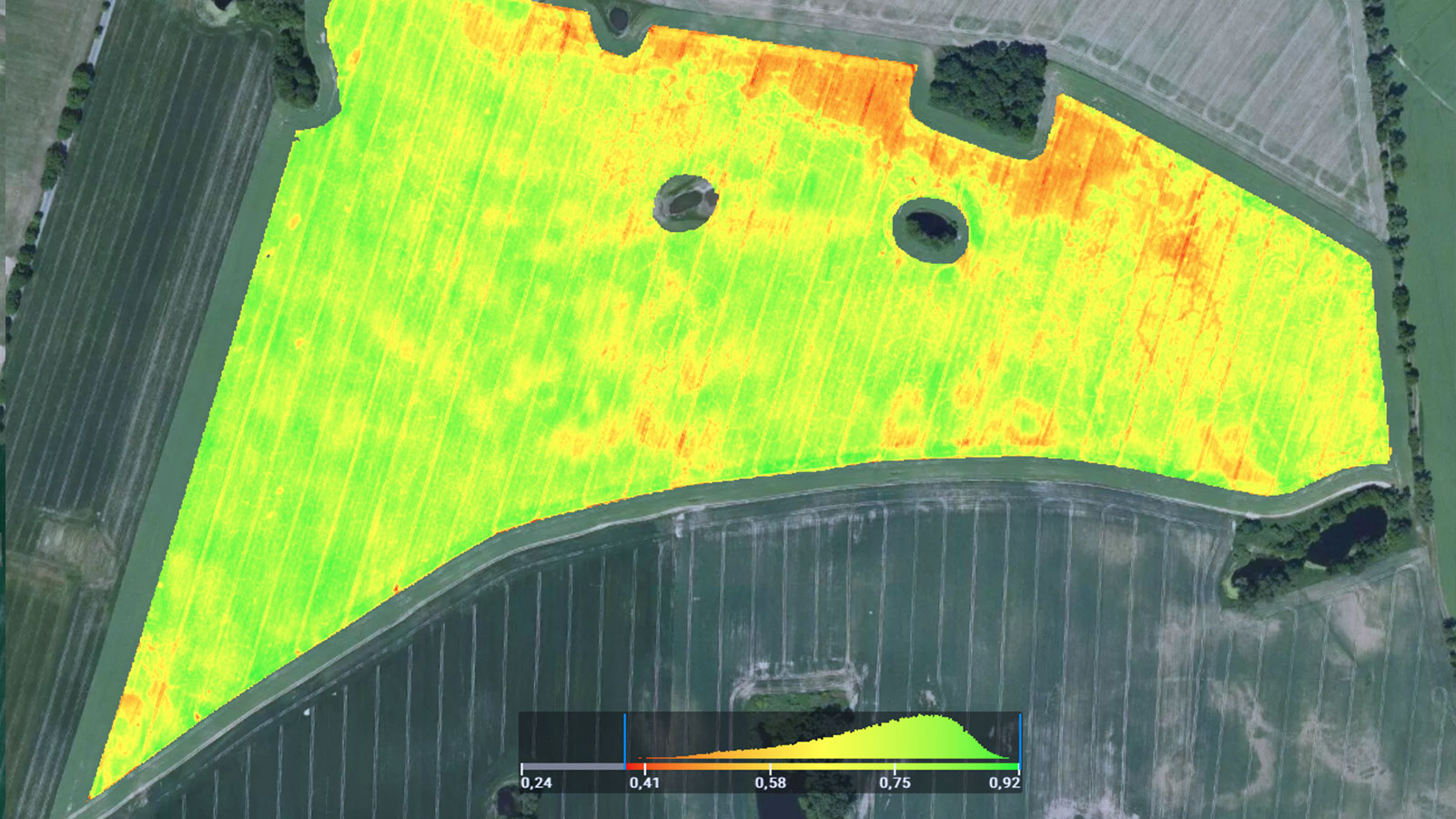
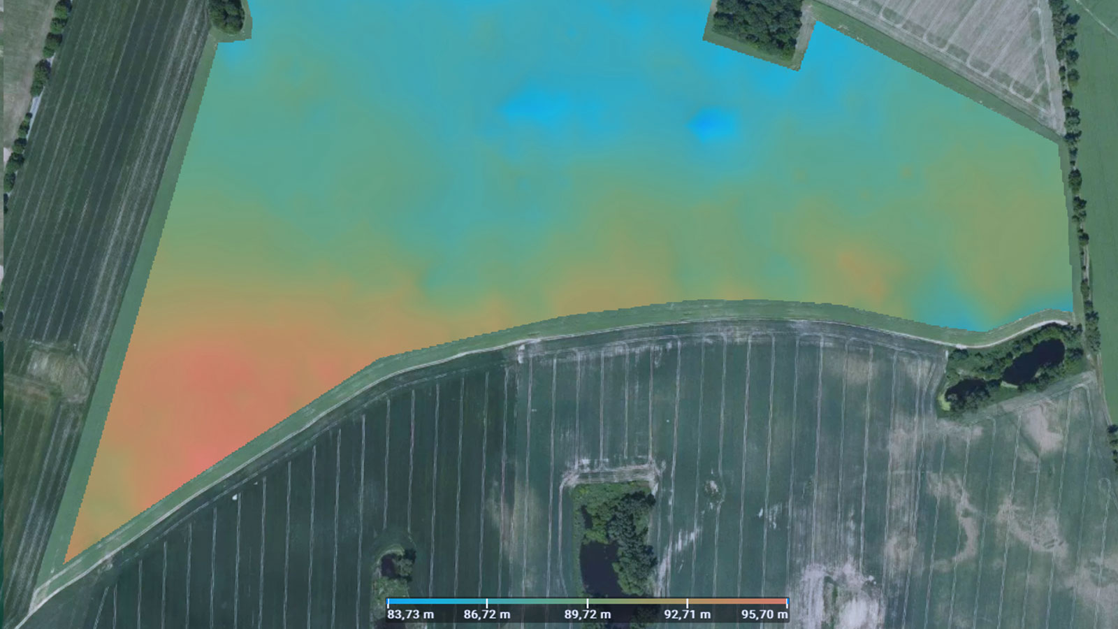
In preparation for the next step, let's look at the non-uniformity we see here in the image data. Unfortunately, without more detailed knowledge of the circumstances of the cultivation, we can say little about it. Soil conditions, diseases, lack of water, lack of nutrients, weed nests, pest infestations - the reasons for non-uniformity can be many and the farmer's experience is needed to correctly identify them.
The goal of this workflow is to secure yields while minimizing the input of chemicals into the environment as much as possible. This applies to every type of application, both fertilization and the use of crop protection products.
In our example, let's assume our decision is to fertilize with nitrogen. According to the local guidelines we plan the amount of nitrogen fertilizer depending on the previous crop, expected yield, variety, and location. As an example calculation we assume a maximum allowance of 160 kg/ha of pure nitrogen for the field, which we want to divide into 3 doses. Local guidelines do not specify how this total quantity is to be distributed on the field, so there is an opportunity here to apply more or less per subarea as required, as long as the total nitrogen quantity for the whole field is in compliance with the law.
Partial area specific application
The heterogenous field development, which can be clearly seen in the NDVI, now helps us to plan fertilization on a site-specific basis. If you don't have an expensive multispectral camera at your disposal, you can also work with an inexpensive consumer photo drone, calculate a TGI index in PIX4Dfields from the RGB maps, and you will usually be able to see growth differences quite well already.
Based on these index maps, we first want to group sub-areas with similar properties. For this purpose, we select four zones in normal resolution in the zonation tool of PIX4Dfields.
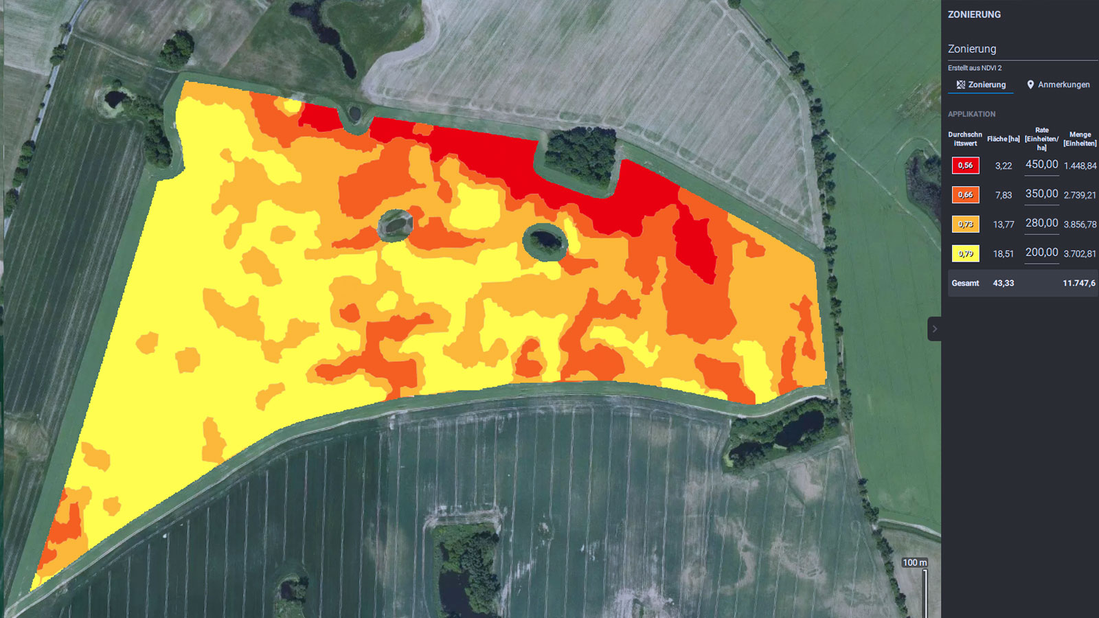
In our example we plan a starter dose of 70 kg N/ha. For a 45.28 hectare field this results in a maximum of 3.2t of pure nitrogen, or if fertilized with calcium ammonium nitrate (CAN) with a total amount of 11.8t. This was distributed to the 4 zones accordingly. As a first approach we chose a variation of 10-15%. In areas with good development we want to fertilize less and strengthen other, weaker areas. Then for the second and third application we reverse the scheme.
PIX4Dfields calculates the total treatment requirement for the process. We then change the numbers until we reach about 11.8 tons. Then we export the data in a suitable format to a USB stick for the terminal and the fertilization can start.
While insects are usually associated with negative effects on the crops, there are many (pollinating) insects such as bees, butterflies, and flies that play a big role in crop cultivation, especially for fruits and vegetables. Remote sensing and precision agriculture software such as PIX4Dfields can help farmers optimize their inputs and reduce the insect-harming chemicals on their fields, which is better for the overall health of the local ecosystem.


