
Internet of Fields: Drones & variable rate application
Tailoring the amount of fertilizer on crops is good for plants, good for the planet, and good for profit margins.
For variable rate fertilization to be most effective, farmers need an overview of their fields. That’s why more and more farmers use drones and precision agriculture for creating prescription maps.
In this post
- Use case: Variable rate nitrogen fertilization in Germany
- The benefits of variable rate fertilizer application
- Drone mapping for VRA
- Use case: Field-specific growth regulator and pesticide applications
- Seeing the invisible with multispectral cameras
- A precision agricultural toolbox
- Use case: Mapping the optimal harvest time for silage maize
- Use case: Using drone mapping for crop insurance
- Getting started with precision agriculture
Use case: Variable rate nitrogen fertilization in Germany
Nitrogen is the most used fertilizer input worldwide and a key component of chlorophyll, without which plants simply can’t thrive. Yet farmers throughout Germany are striving to reduce their use of the compound in alignment with environmental goals.
To get the plants the nutrients they need while reducing overall use of nitrogen, farmers are turning to precision agriculture: drone mapping and prescription maps for variable rate fertilizer application.
The benefits of variable rate fertilizer application
Variable-rate fertilization offers considerable advantages over the more traditional “blanket” applications.
- Variable-rate application (VRA) meets the needs of individual plants by delivering as much nutrition as they need - and no more.
- VRA prevents over-fertilization, which in the short term can burn roots and actually stunt growth. In the long time, over-fertilization can speed up soil acidification, affecting growth in the seasons to come.
- VRA reduces nutrient runoff, protecting streams and waterways.
- Applying only as much fertilizer as the plant needs means using less over all - which can be a significant cost saving.
Drone mapping for VRA
Agrarpohl has years of experience creating field-specific variable rate application maps for the customers throughout Germany. Working closely with clients, the Agrarpohl team evaluate and review drone maps which are then transformed into zonation maps for the fertilizers and sprayers.
Soil, weather, and crop variety all affect plant growth, but the variable rate fertilization doesn’t change.
The first step is drone mapping. The advantages of drone mapping in precision agriculture are varied, but include:
- Drones can be used even in cloudy weather.
- Regular field overviews allow a faster response to crop issues.
- Drones can be used in large or small fields.
- Drone maps allow exact planning of fertilizer quantities.
- Field-specific application helps farmers to increase yields.
Drones are one tool among many, but for the next generation of farmers, they will become ubiquitous.
Use case: Field-specific growth regulator and pesticide applications
Understanding and mapping in-field variability is critical ahead of each fertilization application.
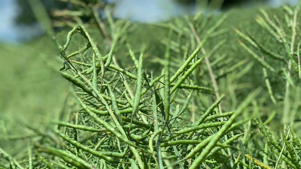
When growing rapeseed, variable-rate application of nitrogen in spring is key. Weather is never the same year to year, and because of this, fields often develop very differently, resulting in un-uniform harvests that translate into unpredictable profits.
Similar issues apply to cereal and vegetable crops, and the ability to map and generate variable rate application maps right before the fertilization is key to more predictable and uniform harvest.
Seeing the invisible with multispectral cameras
Multispectral cameras like the Parrot Sequoia+ or MicaSense RedEdge help to make the invisible visible. These cameras integrate with specialized agriculture software which converts the information into meaningful data.
When it comes to crops, we know the importance of “boots-on-the-ground” so we developed Pix4Dfields to bridge the gap between the visible and the invisible - helping deliver further data to your existing workflows.
A precision agricultural toolbox
A new way of working makes new tools necessary. Each farm is different, but these tools will work in the majority of cases.
| Drone | Choose a fixed wing drone such as the senseFly eBee for very large farms. For smaller farms, a rotary drone will work well. |
| Software | PIX4Dcapture for planning drone flights PIX4Dfields for processing and analyzing |
| Service provider | Working with a service provider like Agrarpohl can take the guesswork out of creating prescriptions. |
| Smart tractor or other dispenser | Smart tractors make it easy to apply the prescription to your fields. |
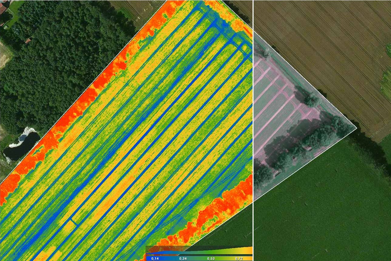
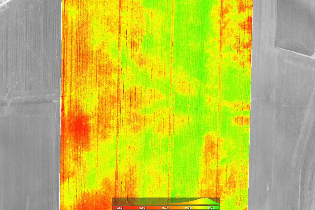
Depending on the chlorophyll content and amount of biomass, plant population reflects light to varying degrees. The sensor on the drone measures the reflected light, and Pix4Dfields converts that information into maps that represent different growth stages.
High NDVI (Normalized Difference Vegetation Index) values mean a high concentration of biomass. The amount of growth regulator such as fertilizer must then be increased because the leaf area is larger and vice-versa.
Many years of Agrarpohl’s own tests and trial plots have confirmed the total application rate reduction when using preparations variably, while at the same time benefiting from yield increases. Over the years, they earned 40 euros/ha more with the variable application of growth regulators.
Use case: Mapping the optimal harvest time for silage maize
It’s an issue as old as agriculture: when is the best time to harvest? Too soon or too late means taste and nutrients are lost - as are profits.
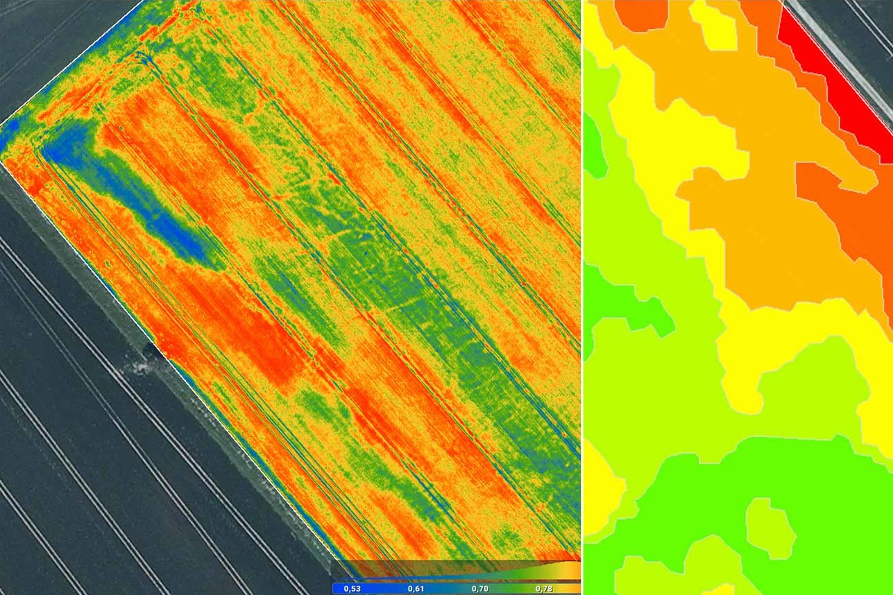
To determine the optimal harvest time for silage maize, Agrarpohl relies on drones and Pix4Dfields. Agrarpohl has created a custom index to measure the ripening of plants in a corn field (for silage), where optimal moisture level is between 60-70% moisture (30-40% dry matter). Corn harvested below 30% usually has too little starch in the corn. If it exceeds 35%, higher losses can occur during storage.
With traditional dry matter monitoring, the dry matter content of randomly selected plants per field was analyzed and then extrapolated for the entire field. This resulted in large variability.
Due to soil differences, for example, the plants often ripen faster in areas with low water retention capacity than in better areas.
In Pix4Dfields, the spatial resolution is extremely accurate. This allows the precise evaluation of individual fields or only parts of them. Plus:
- Targeted dry matter sampling from any part of the field
- Variety independent - works with any crop
- Determine and optimize harvest sequence and logistics
- Quality assurance of the optimal harvest date
Use case: Using drone mapping for crop insurance
Drones in agriculture are used for more than just VBA. They are also used for insurance. In the Midwest United States large rain events are common in the summer, saturating and then flooding the ground. Drainage is important in Iowa but it is often not sufficient for larger rain storms.
| > Full use case: Using drone mapping for crop insurance |
When damage occurs, farmers (policyholders) need to file a written notice of damage to be eligible for coverage. The written notice of damage or loss usually needs to be filed within 72 hours and initiates a claim procedure. This is what ultimately decides if the farmer gets paid or not.
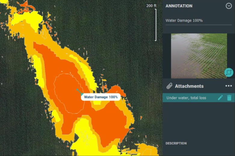
Typically, after an insurable event such as a flood, infestation or storm, inspection is carried out manually. First damaged areas are identified, then manually measured with such as a measuring wheel or tape to estimate the total area impacted and to calculate economic impact.
A third-party loss adjuster will fly a drone over the damaged areas and collect the data. The data can be processed in software such as Pix4Dfields to create a set of visuals based on which they can then assess the damage and create a PDF report for the farmer with the findings.
By using drones for insurance, farmers can get verifiable proof they can use for their compensation. And on the other hand, insurance companies positively stand out in the industry as the main stakeholders in helping farmers recover and stay in business after a disaster.
Getting started with precision agriculture
Like all new fields, precision agriculture and drone mapping can be overwhelming at first. Not sure where to start? Claim your free trial of PIX4Dfields (explore the demo datasets if you don’t have a drone), or reach out to our team. We’re happy to help.


