

How farming was affected by the Queensland 2022 floods
On February 22nd 2022, the Queensland area was hit with a torrential downpour of rain. In the worst flooding event since 2011, this same rain event would later see Sydney received a month’s worth of rain overnight. 20,000 homes and businesses in Sydney alone and tens of thousands more in Regional NSW and Queensland flooded and the government declared a national emergency.
When the floods hit, Joseph Canning of Hawkeye Access was cut off for 3 days in his home. Hawkeye Access is a specialized drone service provider working in Gatton, within the Queensland area. Joseph Canning, the company director, has been working with drones for years and started using PIX4Dmapper in 2017. In 2022, he still uses it for 80% of his work. His experience with photogrammetry includes measuring volumes of feed in fields for dairy farming.
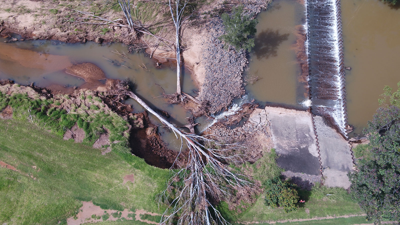
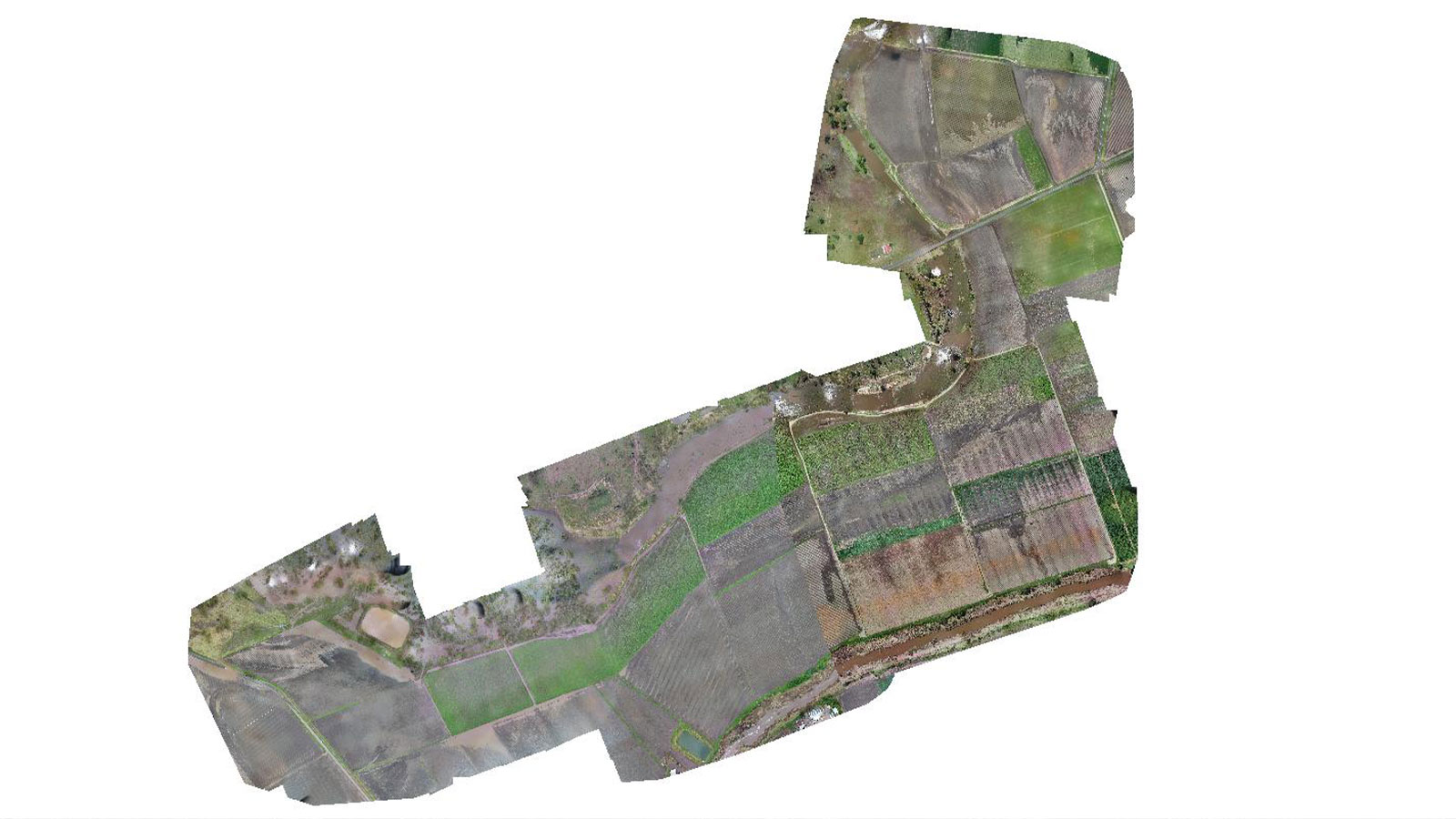
When Joseph was able to move about again, he volunteered to use his drone surveying to assist farmers in the area near the Lockyer Valley to assess the damage. He offered to fly his drone over their farms to measure soil erosion and displacement. Drones are often used as public safety tools to assess damage in emergency response and public safety scenarios. In this case, the sheer volume of water in the floods meant that significant quantities of earth moved and changed the landscape. The region of Toowoomba is a foodbowl, providing lots of fast growing crops such as lettuce. Farmers can produce 4 to 5 different crops in the year through careful planning and rigorous harvest schedules. The topsoil, the upper 10% of soil, is the most important layer of earth. It has the most nutrients in it as well as the majority of plant roots. In the Lockyer valley, this critical layer was completely stripped from some areas. Joseph wanted to help understand just how much had moved.
Project details
| Location | Lockyer Valley, Australia |
| User | Hawkeye Access |
| Area surveyed | 13 km2 |
| Software | PIX4Dmapper |
| Flight hardware | DJI M210 RTK, X5 and X7 camera |
| Images captured | 19,000 (180 GB datasets) |
| Processing hardware | Custom PC, 64GB RAM, 1060 Graphics Card |
| Volume measured | 2.12 million meters3 |
Drone mapping a natural disaster
The extreme flooding was likely exacerbated by the weather cycles of La Niña and El Niño, and it left the land devastated. With 250ml of water falling in 4 days, the floods broke the banks of the Lockyer river and overwhelmed the surrounding farms. One poor cow was swept away and found in the river channel 100 kilometers (60 miles) downstream, alive but somewhat confused.
To aerially map the flood damage, Joseph traveled to farms with his M210 drone. It is an RTK enabled drone so he knew he would be able to get accurate results to complete volume measurements during processing. The flights were spread out across a 13 square kilometer area near the river that had been hardest hit. Joseph worked with farmers to analyze which parts of their farms had been hardest hit. One issue they discovered was that farmers who had not yet harvested crops had their plants destroyed by soil movement. However, farmers who had harvested their plants had almost entirely lost their topsoil layer which was washed away because no plants roots were holding it in place. This is a problem that can also cause landslides in heavy rain.
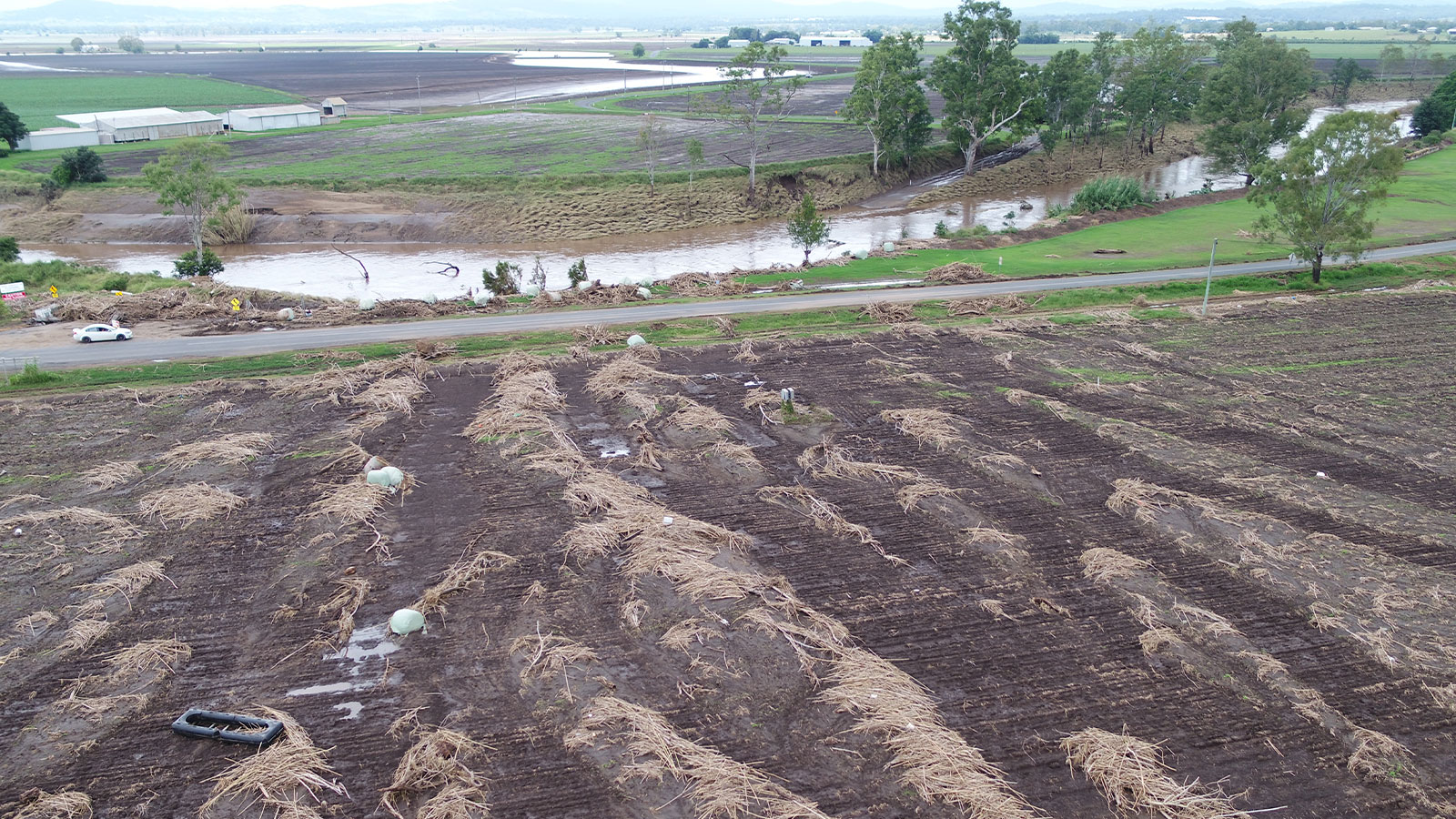
Farmers along the river had contoured their fields with lasers to optimize drainage. Those systems are not designed to cope with flooding on this scale, and there were 20 centimeter steps carved down the slopes. Further downstream, some farmers had exponential soil deposition on their land that created huge piles on their land.
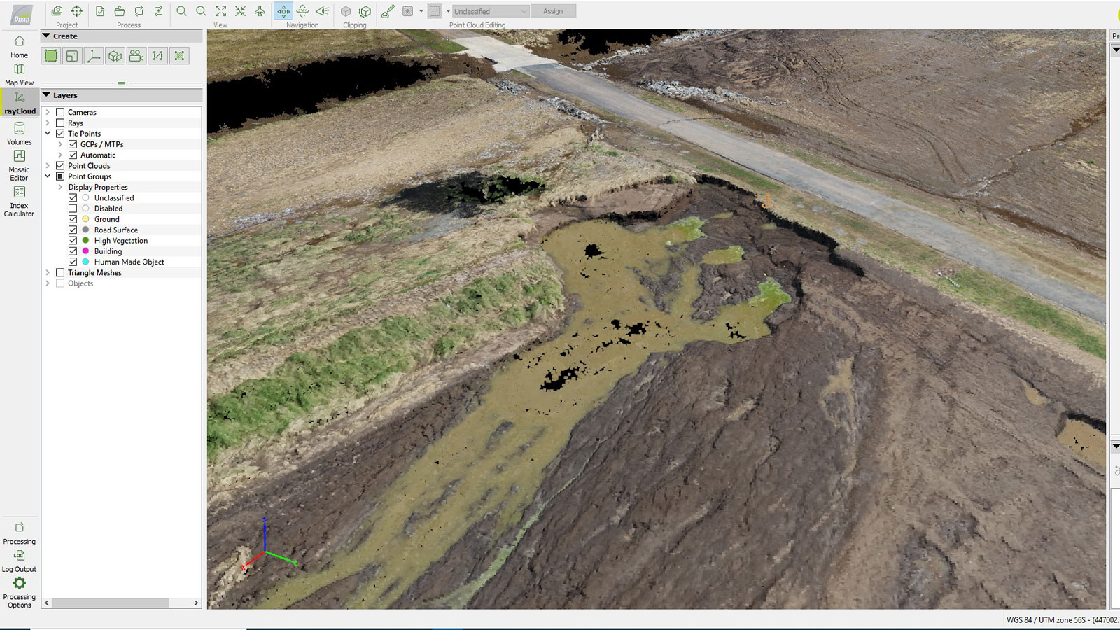
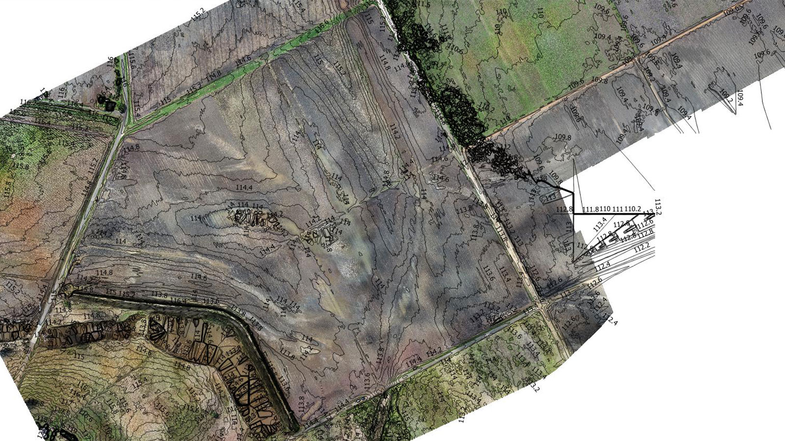
Once Joseph had gathered the various datasets, they totaled 19,000 images. He broke these down into smaller chunks that were about 2,000 images each for processing with PIX4Dmapper. The maps and outputs Joseph created were specific to each farm. Processing and data collection combined took 20 days across the whole area.
Quantifying soil displacement after a major flooding event
PIX4Dmapper has accurate volume measurement capabilities which have been used previously in emergency response in the aftermath of the Australian Wildfires in 2019/2020. This time, Joseph was providing terrain analysis for use in damage assessment and agricultural insurance claims.
In numbers, the Queensland flooding devastation is immense. Joseph measured an average of 120,000 cubic meters of soil loss per 80 acres (32 hectares). Each cubic meter is worth 1000-1500 Australian Dollars in investment (650 - 1000 USD). Across the entire area, Joseph measured 550,000 cubic meters of soil being displaced from a single farm of 80 acres. He surveyed 13 Million square meters of land and saw that 2.12 milion cubic meters washed off directly, whereas some areas were covered in deposition from the floodwaters. The estimated soil loss in the Lockery valley would bury London City 45-60 centimeters deep in soil across the area (3 km2).
Joseph handed back 685 GB of data to farmers across the area. These included PDF reports that quantified the volume calculations from drone imagery as well as photos of the farmers and annotations. Joseph has also stored all the imagery he gathered because Australian law dictates that any aerial photo must be stored for 10 years.
Damage assessment after a natural disaster
The measurements and data provided by Joseph have been used by farmers in the area to understand the scale of damage they suffered in the floods. All results were returned within 30 days (including the data collection and processing over 20 days).
Joseph’s maps will be used for agricultural insurance claims and farm records of what happened. They could also be used by officials as part of their recovery efforts and supporting local farmers.
“Without the support of Pix4D this service would not have been available as quickly. The assistance from the Pix4D team was greatly appreciated and overwhelmingly supportive. Thanks from all the farmers and supported businesses is sent to the entire Pix4D team.”- Joseph Canning, CEO Hawkeye Access
The situational awareness provided by the drone surveys was massively helpful to the farming community and an innovative way to use drone mapping software to complete aerial surveys and analyze significant terrain changes. This modern form of data collection served the local community and allowed Joseph to volunteer his specialized skills as a resource for recovery.


