
Assisting climbers with photogrammetry and 3D models
Before a mountain can be climbed, it has to be found.
To find a rock climbing route, climbers currently rely on hand-drawn topographic sketches, and written descriptions in guidebooks. Photogrammetry allows people to visualize routes and climbing areas the same way they’re experienced - in 3D.
Climb Assist cofounder Brian Uyeno explains: “We believe these models improve route finding abilities and help people spend less time looking for a route and more time climbing. Rock climbers can use our models and website to research an area like never before.”
Project details
| Location | Boulder Canyon, Colorado, USA |
| Company | Climb Assist |
| Hardware | DJI Phantom 4 Pro |
| Software | PIX4Dcloud |
| Images | 100-200 images per dataset: approximately 1,500 in total |
| Processing time | 1.5 hours per dataset |
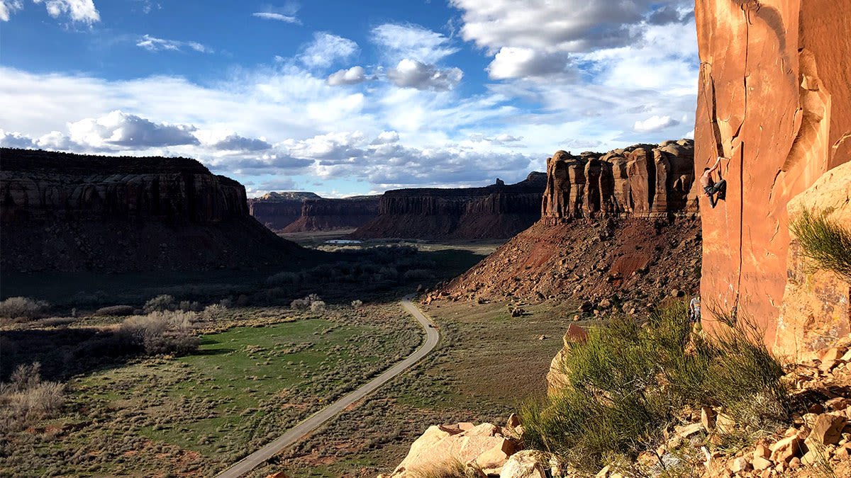
Bouldering in Boulder Canyon
Climb Assist maps climbing routes for popular areas in the USA, including California, Colorado, Utah and Washington.
With guidebooks on the area published since at least 1961, a lot of information exists about Boulder Canyon. The climbing spot is located only a few minutes drive out of town, and is well known to the locals.
But people new to the area may struggle to understand directions published on popular climbing sites, such as: “It should be easy to cross the river on a huge tree that lies across it. [The climb] is directly above... Go left on a path, then back right when feasible up a ramp that leads to the ledge going under the base of the route.”
What is difficult to describe in text, is easy to see in 3D.
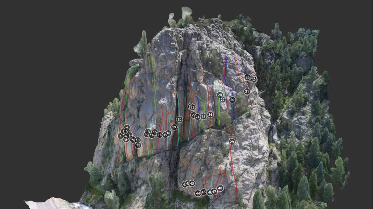
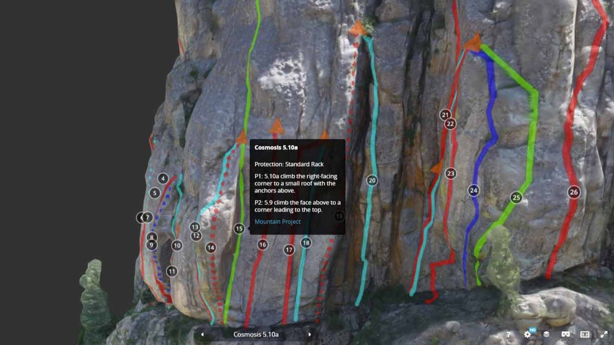
Annotations placed in PIX4Dcloud make the climbing route (in this case, number 15: Cosmosis) easy to spot and compare to others in the same area. The annotations are linked to the same climbing website, so enthusiasts can share their experience and view others photos of the climb.
Climbers can even view the model with VR glasses! But before rock climbers can view the model, it has to be created.
Getting above it all
“Before flying, calling local agencies, land owners and various municipalities such as the State Parks or National Forests is always our very first step,” says Jimmy Uvodich, Climb Assist cofounder.
“Drone flight restrictions or special permit are required in a lot of areas so that’s always a part of the process and does add some restriction on what we’re able to create.”
Boulder Canyon represented a challenge for the team. Uyeno explains: “The tough things were finding a place to take off - a lot of climbing areas are on steep uneven terrain with potential obstacles like trees or boulders.”
As well as being potentially hazardous for the drone, trees can cause issues when processing a project.
“Another issue was trying to fly at a time when climbers aren’t on the wall so I’m not disturbing them,” Uyeno continues. “Since Boulder Canyon is close to town, it was hard to find a time when people weren’t climbing even during the week. I found it was best to go very early in the morning to try to get the flight done before climbers got out there.”
“Capturing and processing Boulder Canyon was quite a quick process, maybe taking 20 hours total for the 50-odd routes. Pix4Dcloud was very straightforward and easy to use. I pretty much just had to upload the photos and set the model quality to something that can be reasonably handled through a standard internet connection. Cross referencing the results and adding the route information to the models after they were processed took a lot longer!” says Uyeno.
Building a community
As well as helping the climbing community, and sharing beautiful parts of the world, Climb Assist is also demystifying photogrammetry and encouraging more people to get into drone mapping.
�“To our knowledge, no other company has attempted to do this for rock climbing, and we are excited to see where it can go,” says Uvodich.


