
PIX4Dmatic 1.47: open photogrammetry format, and many more
PIX4Dmatic is the optimized software for professional drone and terrestrial mapping, rapidly evolving to offer essential functionalities for professionals. The latest developments include Open Photogrammetry Format, a brand new standard for photogrammetry file formats, offline licenses for professionals who require or want this function, and a new language. In addition, in PIX4Dmatic, the user can now scale and orient their project manually. Read about these and more improvements below!
Open Photogrammetry Format: the PDF of photogrammetry
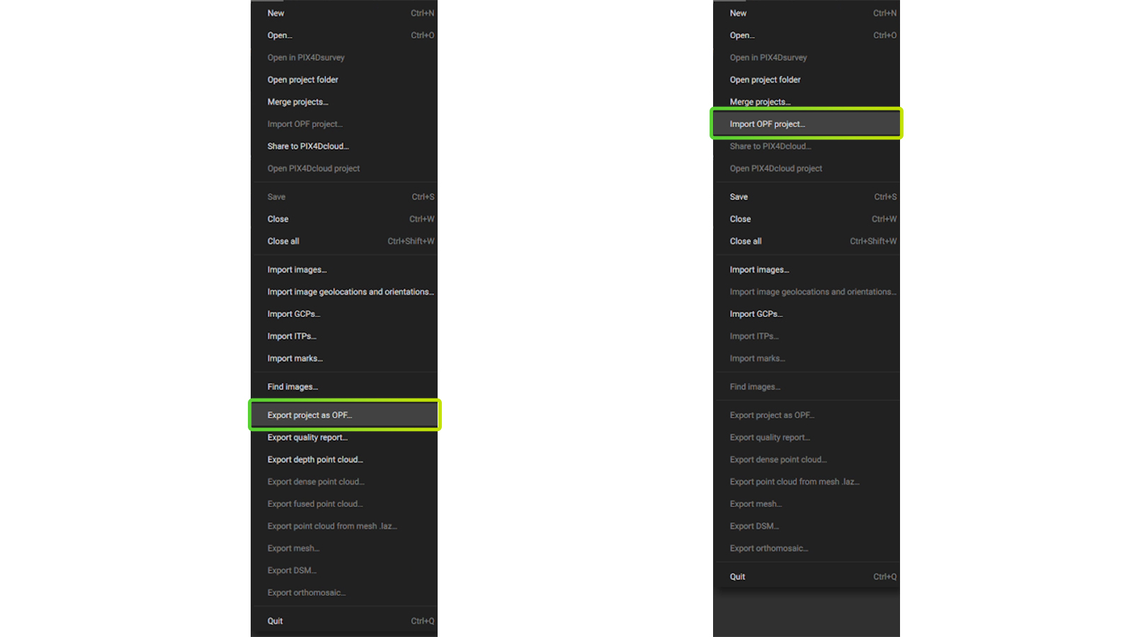
Open Photogrammetry Format (OPF) is a fully open and free specification that allows for storage, exchange, and collaboration on photogrammetric data, even for software developed by different companies. The data stored in OPF is related to a photogrammetric 3D model and includes information on both inputs and outputs of the process. This new file format addresses the need for a standardized and open format for storing and sharing photogrammetric data. It can be used by researchers, academics, and professionals who require a standardized and efficient way to manage and share photogrammetry projects. Read our dedicated Pix4D Labs article about OPF and learn more.
Work offline with a new type of license
For some professionals, operating online is not an option. Police, public safety, and critical infrastructure need to work offline due to the high importance of data security. Following up with this request, PIX4Dmatic has a new, fully offline licensing type that does not require an internet connection. Getting updates and notifications is done manually. The license is available for perpetual use, a 3-year subscription, or a 5-year subscription. Read the support article or contact sales for more information.
Scale and orient your project
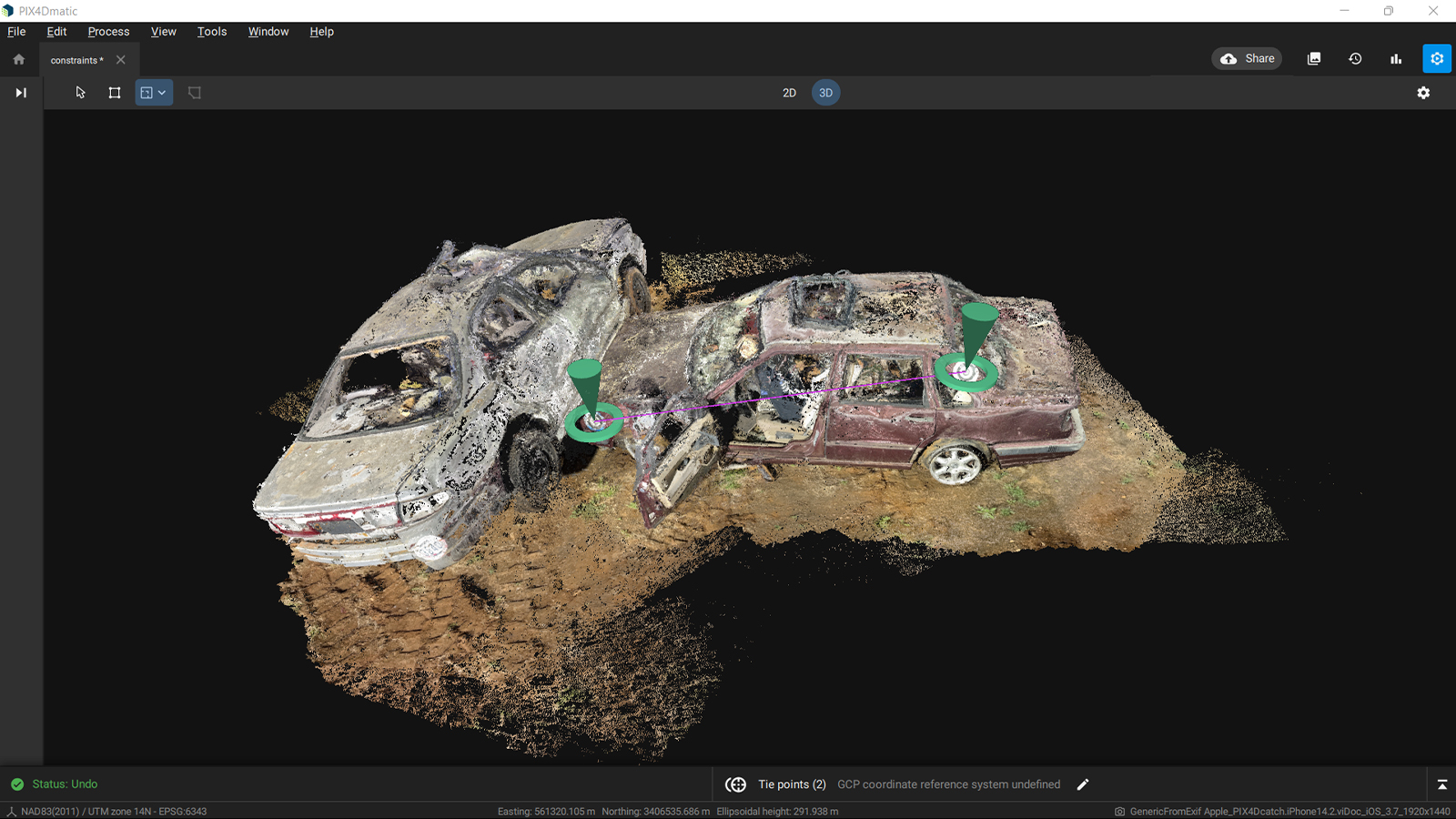
Some projects without accurate geolocation still require highly accurate and reliable results. For example, when investigators work on collision reconstruction or crime scenes and present photogrammetric deliverables to the court, they must be highly accurate and well justified. Acquiring Ground Control Points (GCPs) is not always an option, which is a factor that would decrease the accuracy of the project. In addition, it’s not uncommon, especially for terrestrial projects, that DSLR or mirrorless cameras that don’t have geotags are used. As a result the final project is not correctly oriented, especially in the Z-axis which often exhibits a tilt that can significantly affect the project. The latest PIX4Dmatic version includes two valuable tools that ensure desired accuracy and correct orientation: the scale and the orientation constraints.
The scale constraint allows for the correct scale to be applied to the whole project: just draw a scale constraint between two points, define the accuracy, and the project will scale according to this distance. The two points have a known distance between each other (a tape or points whose distance was measured on the site, thus very reliable to be used as a scale).
The orientation constraint is defined by two points on the point cloud whose direction can be assigned to the X, Y, or Z axis. The orientation is applied to the project and the model now has the correct orientation. The points can be manual tie points or intersection tie points as both are very reliable in defining the Z axis.
By incorporating these constraints, the scale and orientation of the 3D model is manually adjusted to reliable measurements and accuracy is improved.
SSO login, new geoids, cameras, and a new language!
With the new release, PIX4Dmatic supports Single Sign-on login for enrolled organizations, facilitating the work of enterprise customers. Also, PIX4Dmatic is expanding the list of supported geoids that are used by surveyors all over the world. The new additions are the GCG2016 geoid model of Germany and the SLO_VRP2016/Koper geoid model of Slovenia. In addition, the list of supported camera models now also includes:
Want to learn more? Check our online and onsite workshops. We also have the brand new PIX4Dmatic Essentials online course and the Collision Reconstruction with PIX4Dmatic online course, ideal for public safety professionals. Download PIX4Dmatic now and try all the new improvements and functionalities!


