How is drone mapping used for crash investigation
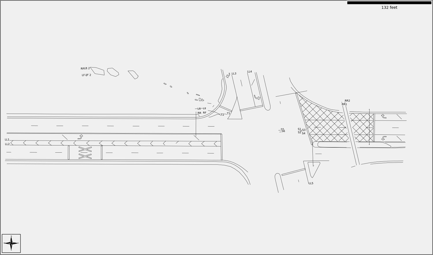
In the small hours of a January morning, a speeding vehicle veered off a major road and struck a streetlight, killing the passenger. The posted speed limit was 30 mph. The responding officer took 61 photos with a Nikon DSLR, including 18 that captured the yaw mark left by the tires on the roadway. At the time, there was insufficient evidence to determine the speed of the vehicle.
Nearly a year later, Pix4D’s premium reseller Aerial Metrics were asked to fly an sUAS mission at the scene and combine the photos taken from the drone with the original DSLR photography and build a model with Pix4Dmapper. From the model, the Aerial Metrics team was able to measure the length and curvature of the yaw mark and determine a range of possible speeds for the vehicle -- in excess of 60 mph. This evidence allowed charges to be filed against the driver, which would not have been possible without this technology.
Aerial Metrics co-founders Iain Lopata and Stan Taylor sat down with Pix4D’s Caroline Bailey and Angad Singh to discuss their work and tools for crash investigation and other public safety projects.
Pix4D: Thanks so much for chatting with us! Let’s start with a few words about your company.
Aerial Metrics: We wanted to explore the potential for the use of small unmanned aerial systems (sUAS) to improve the process of crash investigation. So together with the Lake County Major Crash Assistance Team (MCAT) we developed a system that employs sUAS and photogrammetry to reduce road closure times, improve officer safety, and capture better evidence at crash scenes.
Pix4D: Tell us a bit more about your workflow in the field and what it consists of.
Aerial Metrics: Our workflow in the field is very consistent from scene to scene. Here’s a quick breakdown:
This workflow has been developed and optimized by Aerial Metrics after years in the field to fit collision reconstruction scenarios, account for real-world obstacles like trees, and ensure more than enough data has been captured before scene cleanup.
1. Once the scene is safe, evidence on the roadway and surrounding areas is identified and marked with spray paint, evidence tents, or versa-cones.
2. We use two or more scale reference measurements taken between easily identifiable points at least 50 feet apart. These are used later to verify the accuracy of the photogrammetric model.
3. Before we start with mapping flights, we do a quick pre-flight check to ensure hardware/software function and regulatory compliance.
4. Three flights are conducted over the scene or subsets at progressively lower heights. The pilots are trained to determine the appropriate heights and photographic overlap distances for each layer. The first and second layers cover the same area. The third (lowest) covers only the area of key evidence and may also include obliques of vehicles. The easiest way to think about it is that the middle run is primary, the higher run is insurance in case of inadequate overlap, and the lowest run improves resolution/GSD for the most critical evidence.
All images are processed in the same project. The flight heights are selected to ensure that the three layers will calibrate together. This workflow reduces total flight time while still ensuring very high-resolution models for capturing even small evidence details such as shell casings.
5. Once the flights are concluded, the evidence and vehicles can be removed, and the roadway opened for traffic
Pix4D: Do you think using drones and Pix4D for public safety is good for society?
Aerial Metrics: Most definitely. The time taken to document crash investigation evidence has been reduced from 2-3 hours to only 15-20 minutes. This translates into:
- Roadways being opened sooner.
- Improved productivity for travellers.
- Reduced fuel consumption from extended traffic delays.
- Reduced secondary crashes from stopped traffic.
- Improved officer safety and demand on their time.
Pix4D: What would you say are the most significant benefits of this technology?
Aerial Metrics: Aside from the time-saving advantages we mentioned, the main two benefits in our opinion of using sUAS and photogrammetry for crash and crime scene investigation when compared to traditional techniques are:
- Full three-dimensional model reconstruction with millions of data points.
- Equal or better accuracy: sub-centimeter accuracy is achievable.
- Retroactive measurement ability. With total station capture, distances to be measured must be selected at the scene. With sUAS capture, any measurements can be made once the model has been created.
- 3D color models are very compelling in court.
- View points can be changed to any location within the scene, showing what a driver or witness would have been able to see.
- 3D models are much more persuasive than 2D line drawings or primitive animations.
Pix4D: Which Pix4D software solution would you recommend for public safety, and why?
Aerial Metrics: We have worked with and would recommend Pix4Dmapper and Pix4Dreact. In fact, a combination of the two works pretty well.
- Recommended for forensic mapping of crash and crime scenes.
- The most widely used software for this purpose in the public safety community and consequently there is a wealth of experience in its use.
- Has been rigorously evaluated; peer-reviewed papers are available from the Society of Automotive Engineers that document its accuracy.
- Its outputs have been widely accepted in court without challenging them.
- Recommended for rapid response mapping missions such as wildfires, SWAT operations, floods, and other natural disasters.
- Simple to use and delivers scaled maps much more quickly than Pix4Dmapper, but without the level of accuracy required for forensic mapping.
Pix4D: When choosing hardware for your projects, what would you say is important to consider?
Aerial Metrics: When choosing a drone, first, we have to consider its purpose. Different drones are better suited for different types of operation; choosing one drone to cover every conceivable mission will drive up the cost of the equipment without a significant increase in capability.
Secondly, new drones enter the marketplace every twelve to eighteen months, so reviewing available platforms is warranted before finalizing a selection. While it’s inevitable that any purchase will quickly be superseded by newer technology, we have generally found that sUAS are serviceable for at least four years with little hardware maintenance unless they are involved in a crash landing.
Pix4D: From your experience, what roadblocks or challenges can a department run into when trying to adopt and start a program?
Aerial Metrics: The general public continues to have concerns about the use (or abuse) of this new technology by law enforcement, which can set back departments’ efforts to implement drone capabilities by years. In our opinion, the keys to a successful rollout are:
- Careful selection of mission; prioritize those missions that have a clear benefit to the public (e.g,. opening roadways more quickly after a crash, SAR).
- Clear procedures defining when, where, and how the technology will be used.
- Early engagement with the community and consistent messaging.
Pix4D: Bad things tend to happen at night frequently; can this technology be used in the dark?
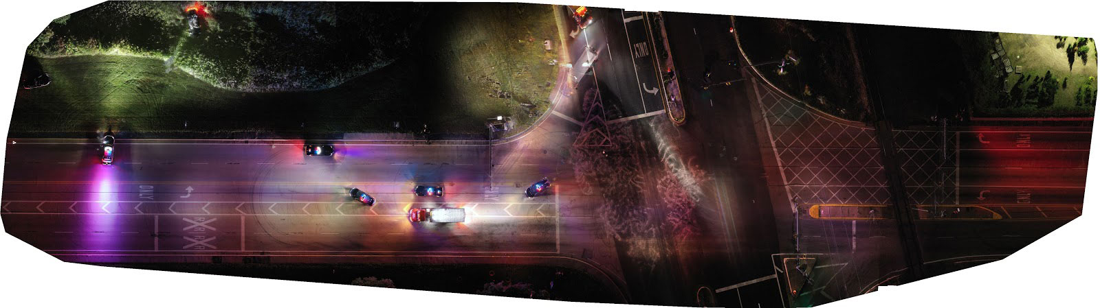
Aerial Metrics: Yes, crash scenes can be mapped at night using sUAS. We have mapped over one hundred scenes at night and use a variety of techniques depending on the specific circumstances and equipment available:
- Street lighting can be sufficient when combined with high contrast paint, chalk, or evidence markers.
- Lighting towers and squad car lights can illuminate evidence areas when positioned strategically.
- Built-in drone or camera light sources usually provide sufficient illumination at typical flight heights of 100 feet and under. The sUAS must be kept still when the camera shutter is activated to avoid motion blur caused by the required longer exposure times.
Results generated with night imagery can be compared with results from images captured during the day. These images should not be processed in the same project but comparing results avoids missing evidence which is not easily identifiable in the dark.
Pix4D: Thank you, Iain and Stan, for chatting with us. This was very insightful!
Aerial Metrics: Thank you for having us!