Pix4Dfields 1.5: Compare results, synced across devices
All crops change over time.
Understanding your crops’ natural rhythm can help you make the best decisions for seed placement, nutrition, and water or fertilizer application. Recording and comparing the changes can help you better understand your crop needs and prepare for the future.
That just got easier with the updated Pix4Dfields 1.5.
Radiometry in digital agriculture
Radiometrically correct values are useful for monitoring and assessment of crop conditions. When it comes to drones and sensors, radiometric correction is required to be able to compare images taken at different points in time, under different weather conditions and to compute reliable index values in the software.
Pix4Dfields 1.5 comes equipped with a new radiometry module which includes support for automatic target detection. Improve your data quality across flights, no matter the conditions.
Pix4Dfield’s radiometry module at a glance
Pix4Dfield’s radiometry module works seamlessly with your data. The results are optimized and improved when collecting drone data.
| Radiometry variables | Camera type | Calibration panel* | Weather conditions |
| Optimize your results | This module is optimized for multispectral cameras: Parrot Sequoia and MicaSense cameras. | Calibrate your camera to measure the correct lighting conditions during capture. | Fly in clear sky or overcast conditions, avoid scattered clouds where possible. |
| Benefit of the module | Automatic detection and radiometric processing based on the camera information provided. | The software will automatically detect the panel images provided. *also works with targetless workflow for Sequoia+ users. | Select your weather conditions during the processing of your data. |
To learn more about the radiometric correction in the 1.5 update, visit our knowledge base.
Introducing data sync
When more than one stakeholder is involved, streamlined and effortless collaboration is essential. In precision agriculture, that collaboration usually happens between the stakeholders in-field and in-office.
Pix4Dfields 1.5 comes with data sync functionality which connects your projects across devices, taking your data from the field to the office.
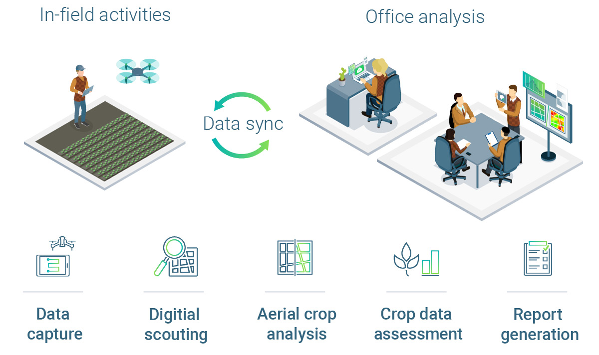
As an example, when in-field data has been collected* you now have the option to sync the project when you are connected to the internet. In the office, another colleague can synchronize the desktop software and seamlessly access the project with the freshly-collected data from the field and continue with the in-depth analysis of the project.
To learn more about data sync workflows and how to use it in the 1.5 update, visit our knowledge base.
*Data sync between a tablet and desktop currently only available with ParrotFields.
Growing season
Watch now our free webinar covering the beneficial ag solution and Pix4Dfields 1.5 new features.
Plus, check out our video tutorials, which will guide you through Pix4Dfields' workflows and features
Pix4Dfields continues to grow and evolve thanks to the feedback and support of our users. Look out for more great things over the coming months!
| More information about the latest version of Pix4Dfields can be found in the release notes. For more details about all Pix4Dfields features check out the product feature list. |