PIX4Dsurvey 1.43: more vectorizing capabilities
PIX4Dsurvey has an extensive toolkit of automated and manual features for quick and accurate vectorization. The latest release introduces automatic roof detection with just a few clicks and the addition of a new automatically detected object type: poles. We have also added more languages to PIX4Dsurvey - you can now work in German and traditional Chinese! Keep reading to learn more and see the most recent improvements to PIX4Dsurvey.
Roof detection with a few clicks
Roofs need to be vectorized and measured (often on a large scale) as part of specific surveys such as roof inspections for solar panel installations and various building or renovation projects. Vectorizing roofs is time-consuming work and can be challenging to do manually as some roofs are quite complicated, with many adjacent or overlapping fields, even on a simple home.
PIX4Dsurvey 1.43 introduces its first automated roof detection workflow. Just click once on each field of a roof and the tool will detect the corresponding planes and vectorize the whole roof, complete with perfectly fitted ridge and valley intersections. You can then refine the vectorization by manually editing the detected roof and ensure that you have all of the relevant information correctly vectorized.
PIX4Dsurvey provides a variety of properties and measurements including the area of each element and the roof’s total space in addition to the slope and azimuth (orientation) of each roof polygon. These measurements are especially valuable for solar panel installations as they provide actionable data on how much sunlight the roof gets. The roof detection tool speeds up the vectorizing workflow and provides complete results that better support planning for the costs, time, and equipment needed for any roof-related project. All measurements can be exported for further analysis and the digitized roofs can be exported to CAD software.

Automatic pole detection
Object detection was introduced in a previous release of PIX4Dsurvey and ever since has been used a lot by our users in use cases that demanded the automatic vectorization of objects such as manholes and drains in large areas. With PIX4Dsurvey 1.43 comes a new addition to the automatically detected objects: poles. Digitizing the base of utility poles is a common part of mapping cities and their infrastructure networks. Governments and local authorities need this information in order to accurately plan extensions of the network or the maintenance of the existing poles.
Detecting and vectorizing poles in large areas is a detailed, difficult, and at times laborious effort in point clouds due to varying resolutions, shade on the point cloud, etc. PIX4Dsurvey can now detect poles automatically in the images and creates markers for every pole that can be exported in multiple formats to CAD. This capability can be also used very well as a pre-site survey.

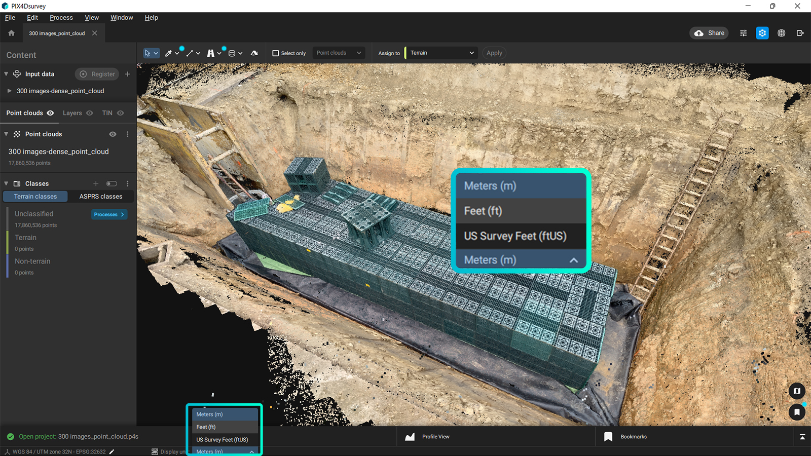
Efficient units display
Often, PIX4Dsurvey users will want to use a different unit system to the processed coordinate system. You can now change the units displayed (meters, feet, or US survey feet) with a simple selection in the user interface and this change is reflected in all the measurements that have already been done and also in the processing tools. This immediate adaptation of the units throughout the user interface allows for a smooth transition between units, according to the needs of every user.
New exports and new languages!
Finally, PIX4Dsurvey 1.43 brings new export options for more flexibility. Export your TIN directly to GeoTIFF to visualize the terrain surface of your project and import it in GIS projects and export your grid points to .csv format for a smooth integration to CAD.
Lastly, at Pix4D we want our users to make the most out of the software by having it available in multiple languages. It is already provided in English, French, Japanese, Spanish, simplified Chinese, and Korean. We are pleased to share that PIX4Dsurvey is now available in German and traditional Chinese.
Download PIX4Dsurvey now to try all improvements included in this release! Leverage information from our Pix4D Support team and Community to learn more or visit our training site to see our latest workshops - one might take place near you! Get inspired by the way professionals from around the world use PIX4Dsurvey and make sure not to miss the current Geospatial Offer for current PIX4Dmapper users!