Pix4D grant: pioneering ideas in academic research
Pix4D recently offered a valuable hardware and software grant to universities: grant winners would receive the PIX4Dcatch RTK workflow, consisting of our terrestrial scanning app PIX4Dcatch with an RTK device, along with a year's access to powerful photogrammetry software PIX4Dmatic and PIX4Dsurvey.
We were eager to see what innovative projects and exciting ideas would emerge for our tools. Applicants submitted proposals detailing how they would use the Pix4D workflow to achieve their project’s vision. We received many applications and it was difficult to choose, but in the end we landed on 12 winners:
Meet the winners

Zdenek Svaty, (https://www.cvut.cz/en) (Department of Forensic Experts in Transportation) [CTU], Prague, Czech Republic
CTU will implement the PIX4Dcatch RTK workflow to improve traffic safety measures. They wish to enhance the procedures at traffic accident sites by gathering accurate data and raising awareness of how modern technology can improve traffic safety. The project aims to evaluate and test the iPhone’s LiDAR technology for traffic accident documentation. The PIX4Dcatch RTK workflow's precise GNSS capabilities make it especially suited for collecting accurate data for traffic safety.

Tobias Bartczak, KU Leuven, Gent, Belgium
In cooperation with the Belgian Ministry for Public Buildings, this project aims to utilize the aerial and terrestrial merging capabilities of the PIX4Dmatic to close existing research gaps regarding steel bridges and achieve clear and accurate 3D representations. They will detect bridge damage by creating 3D models. They have faced distinct photogrammetric challenges when transitioning from concrete to steel bridges, and they believe the merging capabilities of PIX4Dmatic will provide a seamless solution.
Timothy S. Hare, (Department of Sociology, Social Work, & Criminology) Morehead State University, USA
With over 30 years of experience in archeological surveying and mapping, Timothy S. Hare and the Department of Sociology, Social Work, & Criminology wish to transform archaeological fieldwork with the PIX4Dcatch RTK workflow. They aim to speed up image capturing and 3D model generation of archeological ruins. They will use the PIX4Dcatch RTK workflow to quickly map thousands of new ruins recently discovered in the forests of the Yucatan Peninsula of Mexico. With their project results, they wish to gain a deeper understanding of the ancient Maya people and to promote the expansion of archeological field operations using photogrammetry.

Thomas J. Pingel, (Geography Department) Binghamton University, USA
Bringing his expertise in 3D reconstruction, Associate Professor Thomas J. Pingel wishes to facilitate urban renewal. The project explores how new construction can take urban structures and green spaces into consideration with respect to heat, to create more livable communities. He would like to explore the PIX4Dcatch RTK workflow paired with a thermal camera, to create high-resolution thermal NeRFs. Pingel is eager to extend this work using Pix4D’s revolutionary OPF. He wishes to utilize its connection to the NVIDIA NeRF pipeline, as the Pix4D ecosystem enables the maximization of 3D reconstruction while offering greater operator influence compared to other NeRF approaches.
Gabriel Armas, (Planning, Operations, and Construction) Pepperdine University, California, USA
As part of the Common Ground Alliance in the state of California, the Planning, Operations, and Construction Department at Pepperdine University is currently working on the largest construction project in its history. The project aims to modernize the collection of data on campus with the use of drones and the PIX4Dcatch RTK workflow. The research will focus on capturing the construction progress of subsurface utilities through capturing, processing, and merging aerial and terrestrial data.

Nicholas Herrmann & Sophia Mavroudas, (The Forensic Anthropology Center) Texas State, USA
The Forensic Anthropology team from Texas State provides forensic archeology services and training to local and national law enforcement agencies. They send a specialist team, Operation Identification (OpID), to locate, exhume, and identify unidentified migrants who have perished along the US-Mexico border in Texas. They aim to use Pix4D’s tools to investigate missing and unidentified persons in high-impact humanitarian crisis areas. These are along the US-Mexico border in South Texas, the Greek-Turkish border in the Mediterranean, and Soviet-era mass graves in the Republic of Georgia. They would also like to implement Pix4D technology as part of their anthropology/archeology training, casework, and decomposition research.
Sara Zollini, (Department of Civil, Construction, Architectural and Environmental Engineering) University of L’Aquila, Italy
&

Laura Marconi (Department of Engineering) University of Perugia, Italy
Sara Zollini and Laura Marconi from the University of L’Aquila and the University of Perugia respectively, will use the PIX4Dcatch RTK workflow to monitor infrastructure, especially in vulnerable environments such as coastal areas. The aim of the project is fast data acquisition and relatively low-cost processing with lightweight equipment that doesn’t compensate for accuracy - smartphone scanning. The PIX4Dcatch RTK workflow will be used to process images of damaged infrastructure to extract forms of decay (mainly cracks) using machine learning algorithms. The team aims to merge terrestrial and drone data using PIX4Dmatic. In addition, they would like to use PIX4Dsurvey’s object detection to highlight features of the infrastructure and also use its feature tool to analyze the damage.
Andrea Lingua, (Department of Structural, Construction, and Geotechnical Engineering) Politecnico di Torino, Italy
The team from Politecnico di Torino will use photogrammetry for 3D models of the buildings to understand what is needed for green architecture. They will use terrestrial scanning for building surfaces and drones for roofs, bell towers, and the higher parts of buildings. They will use PIX4Dmatic and PIX4Dsurvey to merge the aerial and terrestrial data, obtaining a final accurate and complete point cloud.
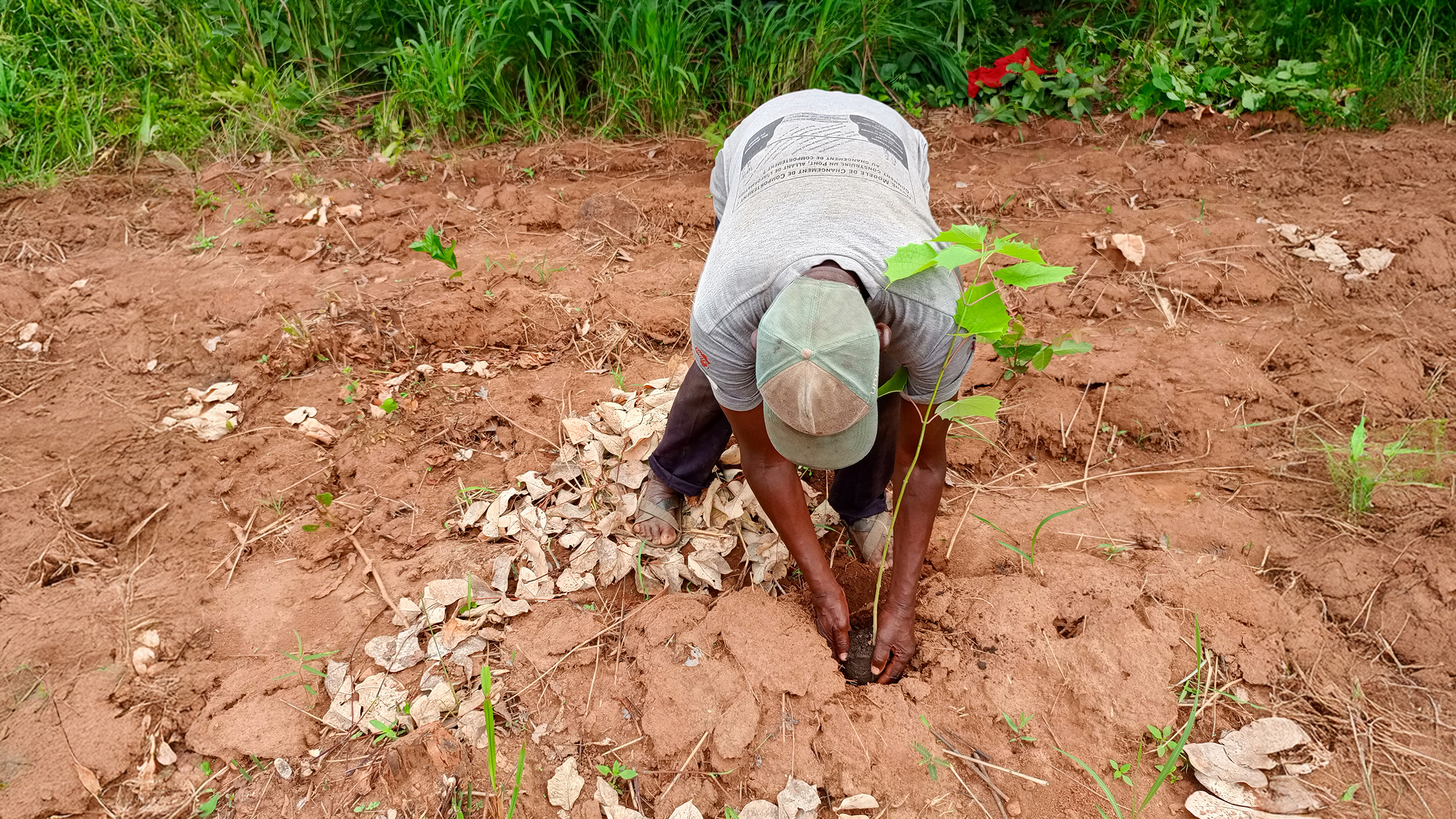
Mykola Skoryk, Zhytomyr Polytechnic State University, Ukraine
Due to the ongoing Russian military aggression in Ukraine, there are restrictions on the use of drones in Ukrainian airspace. This makes ground-based photogrammetric methods such as the PIX4Dcatch RTK workflow crucial. This research project aims to use the PIX4Dcatch RTK workflow, plus PIX4Dmatic and PIX4Dsurvey, for surveying work in open-pit mining environments, particularly through ground-level images.
Hrvoje Tomic, (Faculty of Geodesy) University of Zagreb, Croatia
The Faculty of Geodesy at the University of Zagreb in Croatia is working on a multi-disciplinary research project funded by Oxford Brookes University. The project aims to create 3D models as a way to preserve and document historic wooden structures in the Banija region of Croatia. They will introduce the PIX4Dcatch RTK workflow into their current, relatively complex workflow for comparison. The project aims to develop a comprehensive and multidisciplinary methodology that combines modern technology with traditional architectural documentation techniques to establish a database. They aim to raise awareness about the profound significance of the wooden structures to ensure their preservation.

Zachary Smith, (Department of Earth & Planetary Science) University of California Berkeley, USA
This project aims to understand the physics of earthquake ruptures, with the goal of understanding when and where earthquakes occur so as to minimize the hazardous effects. Smith will use the PIX4Dcatch RTK workflow to capture displacements on earthquake faults and the fracture distribution in the rock surrounding the faults. The data will be processed in PIX4Dmatic. He will use PIX4Dsurvey to vectorize fault and geologic features. Drone flights are not permitted in the project area, so the terrestrial scanning capabilities of PIX4Dcatch will be particularly useful.

Rebecca Fascia, (Laboratory of Geodetic and Photogrammetric Measurements) Politecnico di Milano, Italy
Rebecca Fascia, a PhD student at Politecnico di Milano in Italy, is developing a method for digitally archiving the cultural heritage of Piacenza in Emilia-Romagna. The project emphasizes the shift from traditional methods of documentation and conservation to digitization; promoting real-time, data-driven documentation.
Honorable mentions
We’d like to thank all those who applied for the Pix4D university grant. There were so many fascinating projects, and we would like to give a special mention to these universities:
German Aerospace Center (DLR), Institute for Software Technology; Delft University of Technology, Faculty of Architecture and Built Environment, Geomatics; Politecnico di Milano, Department of Civil and Environmental Engineering (DICA); Forest Science and Technology Centre of Catalonia (CTFC); Presidency University, Department of Civil Engineering; [Ardahan University], Archeology; Technical University of Kenya, Geoinformation and Earth Observation; Leibniz University Hannover, Geoinformatics; [Tecnológico de Costa Rica, School of Architecture and Urbanism];EPFL, Resilient Steel Structures Laboratory, Civil Engineering Institute; IFSC, Electrical Engineering; University of Adama Mickiewicza in Poznan, Geographic & Geological Department; University of Padova, Department of Land, Environment, Agriculture and Forestry; Arab Academy for Science, Technology and Maritime Transfer, Computer Engineering; Savitribai Phule University, Computer Engineering; Cal Poly Pomona, Landscape Architecture; SENA National Learning Service; Nottingham Trent University, Design, Architecture and the Built Environment; Lane Community College, UAS; Pontifical Catholic University of Valparaíso, Faculty of Marine Sciences and Geography; National University of Itapúa; Selcuk University, Architecture and Urban Planning; Federal University of Campina Grande, Mining Engineering; Indian Institute of Space Science and Technology, Earth and Space Sciences; University of Zambia, School of Engineering, Geomatics Engineering; Lycée Norman Foster, Building, Public Works, Topography; University of Delaware, School of Marine Science and Policy; University of Panama, Engineering;