Construction progress tracking with the CraneCamera
The deliverables are used on a daily basis to rapidly detect design clashes or deviations from schedule, and update the project teams on the as-built situation.
Here are 3 reasons why you should also consider the CraneCamera solution.
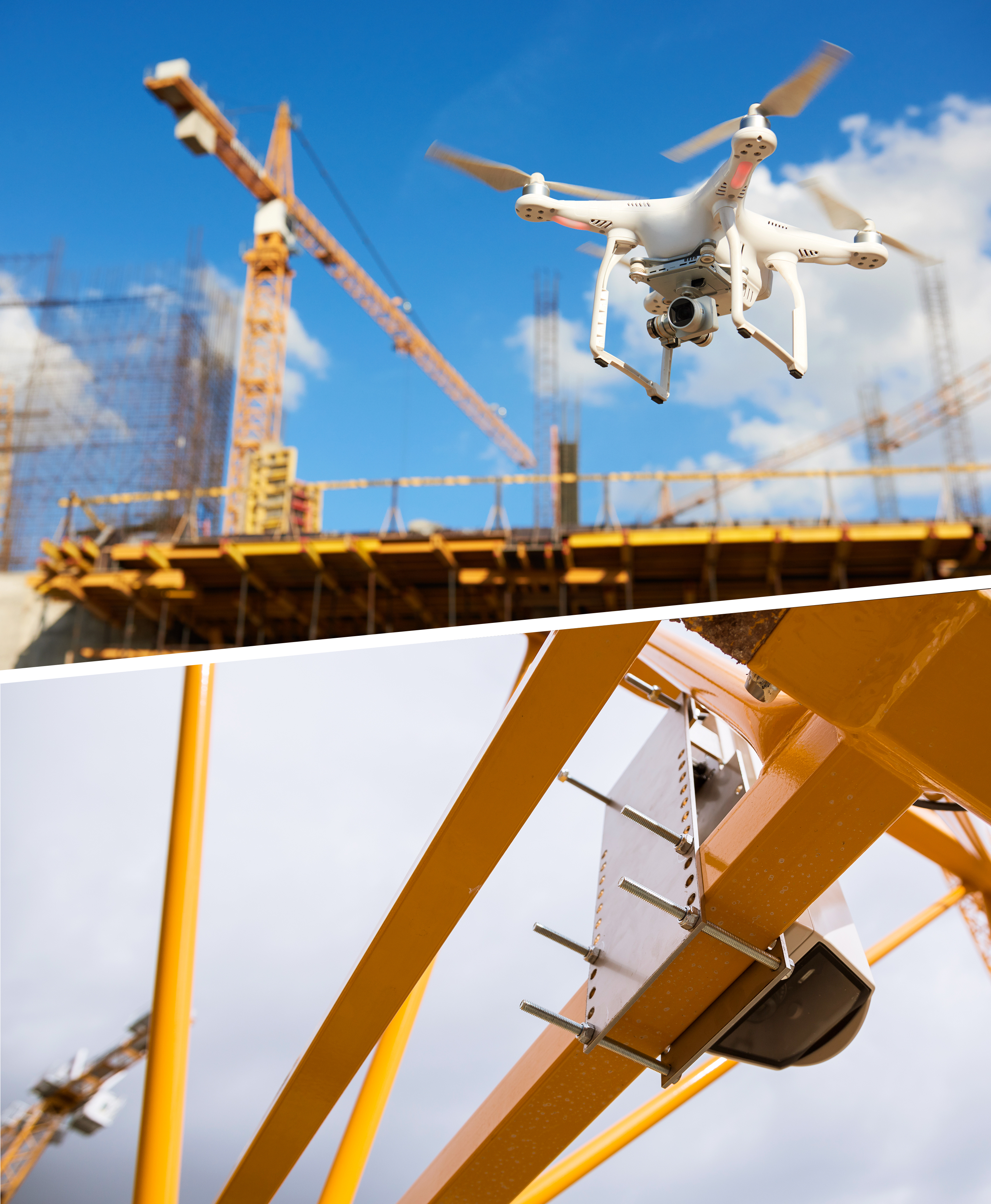
1. Drones have limitations. The CraneCamera doesn’t.
The benefits of using drones on construction sites have largely been documented over the last few years. Combined with a professional photogrammetry software like Pix4Dmapper, drones are a quick and easy way of getting regular site surveys at low cost — in comparison to traditional surveying technologies. However, to be efficient with drones in construction, you have to take into account a few parameters and rules.
Repeatable flights
To be fully valuable when it comes to tracking construction site progress and inspection for design or schedule issues, drone flights have to be done on a regular basis. Because construction sites evolve very rapidly, just one drone flight from time to time on a multi-month and multi-phase project is not enough to give you the full picture at the right time.
Resources and flight permission
Construction companies can choose to fly drones and process results on their own, or they can use drone service providers to fly sites on their behalf and get usable deliverables. In both cases, if you want to fly regularly, it requires resources – human resources and time, or money – and most of all: permission to fly. Depending on country legislation or site location, obtaining flight permission can sometimes be a very difficult process.
Weather dependency
Let’s add another parameter: weather conditions. More and more drone flights must be planned ahead and what happens when the weather is not on your side? You have to postpone your flight and you might not get the data you need at this precise moment.
There is no limitation to the CraneCamera solution.
The Pix4D CraneCamera solution does not have to face rules and regulations nor weather conditions. It doesn’t need human resources or extra costs to run and deliver results. You get 2D maps and 3D models on an everyday basis, and if you wish, you can even get those more than once a day.
2. It’s a stand-alone solution
Feeling overwhelmed by construction technology? The good news is: you don’t need any special skills to be able to use the crane camera solution on your jobsite and the results.
Reliable system
The CraneCamera solution consists of an advanced camera system installed on tower cranes and is connected to PIX4Dcloud Advanced platform. Fully autonomous and powered by the crane, the camera is mounted on the crane jib for the entire duration of the project. The camera system is weatherproof and designed to withstand crane vibrations so it doesn’t affect the system precision nor the sharpness of the images captured.
Fully automated workflow
The camera system is equipped with a firmware configured to automatically collect images of your site every day at the same hour and during the same period of time. It’s easy to control the system and change its settings remotely if needed. The system also includes GPS/IMU navigation sensors that enable the image capture when the crane is operating and also prevent the system from capturing the same image/position twice.
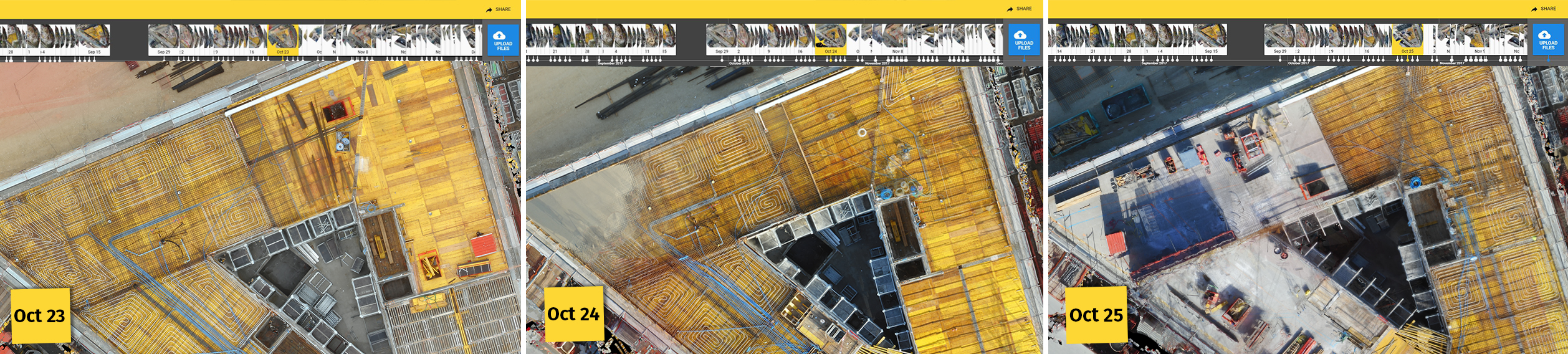
Every day the system automatically collects the images for you and transfers them to the PIX4Dcloud Advanced via a 4G connection or WiFi. This is done during the normal operation of the crane, the crane operator does not have to do anything different from his normal work. Those images are then processed automatically by the PIXcloud Advanced platform to be converted into 2D scaled and georeferenced orthophotos, 3D point clouds, 3D mesh models and 2D elevation maps.
3. Remote as-built updates from multiple sites on a daily basis
The increasing complexity of construction projects has raised the bar on performance and productivity. Managing a construction project to meet productivity targets is not an easy task, especially when you have to manage more than one site at a time. The lack of transparency on the progress situation and the fragmented communication across teams are recurring problems we want to overcome with the CraneCamera solution.
No site access or human intervention required
The solution helps you to save resources and a huge amount of time that would usually be spent on searching for the correct and most up-to-date information on the as-builts. With the Cranecamera, there is no intervention needed on site to perform site surveys and subsequently no work disruption. Once the system is mounted and fixed on the crane jib, you don’t have to worry about it anymore. You don’t have to go on site to collect data or ask for site updates. With this remote access to the as-built situation, you get real-time project visibility. And because everything is automated, you can easily monitor multiple projects at the same time.
Ready-to-use data accessible to everybody
For those who believe a CCTV camera or a standard camera viewing system could do the same job, let’s set the record straight. This CaneCamera is a unique combination hardware, firmware and photogrammetry software which fully automatizes site surveys on a daily basis to get geo-referenced and scaled models.
The daily generated 2D orthographic maps and 3D models are available on the PIX4DCloud Advanced platform where they can be measured, analyzed, compared with CAD drawings, and shared with all project members for collaboration and communication. Outputs can also be exported to third-party BIM software for further analysis, such as clash detection and design verification.