The Beirut explosion: drone mapping for recovery
On August 4th, 2020, Beirut, the capital of Lebanon, was shaken by a huge explosion. 2,750 tonnes of ammonium nitrate in storage at the Beirut port ignited, blowing up with a shock wave that heavily damaged buildings within a 5km radius (3 miles) and devastated the city. 220 people lost their lives, 5,000 more were injured, and around 300,000 inhabitants of the city were left homeless. In a period where Lebanon was already facing a refugee crisis, economic pressure, and Covid-19, the explosion was a disaster that left the world, let alone Lebanon, horrified.
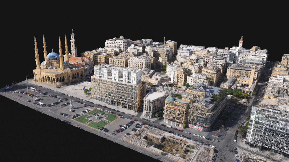
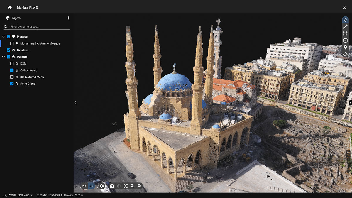
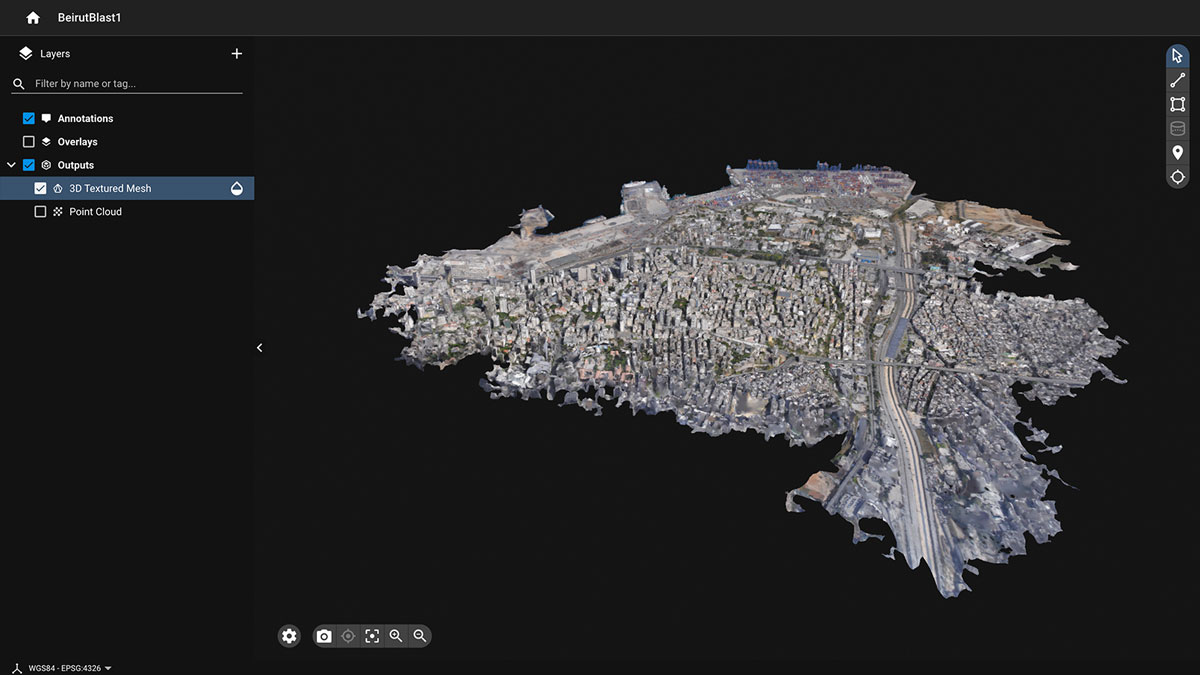
Pix4D was contacted by Augment, a Luxembourg-based company with roots in Lebanon, to help with this project. Augment wanted to help with recovery by providing knowledge through gathering data and presenting it in a form that could be used by other organizations. They were put in touch with Pix4D who recommended they use Pix4Dcloud, a cloud-based photogrammetry software, to process data that could easily be shared either as a dense point cloud, 3D textured mesh, orthomosaic or DSM. Pix4D helped Augment create a detailed and accurate open-access map of the blast area and surrounding damage to the city.
Working with kickstartaid, Live Love Beirut, and several other humanitarian aid organizations, Augment planned the drone mapping of the area with an eBee X drone and several software programs, including Pix4Dcloud.
The key advantages of a 3D model from drone images include:
- Up-to-date information
- Minimal risk to personnel
- Quick deployment/use due to being open-access
- Virtual inspector to analyze the project using full resolution images
- 2D and 3D results for measuring distances, calculating quantities, etc
- Shareable information that can be accessed from anywhere
Project details
| Location | Beirut, Lebanon |
| User | Augment, Open Map Lebanon |
| Total images | 4,306 |
| Software | Pix4Dcloud |
| Hardware | eBee X with S.O.D.A. 3D camera |
| Outputs | Dense point cloud, 3D textured mesh, DSM, orthomosaic |
| Area surveyed | 2.88 km2 |
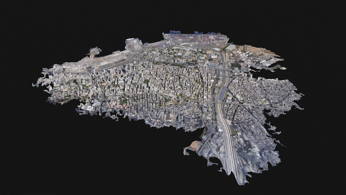
Mapping a disaster site
Videos of the blast circulated online, with before and after satellite images showing major destruction. A 140 meter (460 feet) crater was excavated at the blast site, and a large ship was thrown across the port. At Beirut International Airport, 9 kilometers (5 miles) away, windows shattered. The damage seemed overwhelming and immeasurable.
Drone mapping was a clear option for image acquisition; drones can access and see streets covered in debris and rubble without risking people or equipment. This means it is not only safer but faster too, as airborne UAVs do not need to clamber over rubble and bricks. Working with manned aircraft was not considered as it would require more complicated logistics, such as coordinating with air traffic controllers. This could have distracted or delayed the arrival of emergency supplies or equipment from other flights, which would have been an unnecessary disruption. Carefully planning a flight also saves time and resources.
In terms of hardware, Augment was assisted by Geospatial Minds and their partner Falcon Eye Drones (FEDS), who used the senseFly eBee X with the S.O.D.A. 3D camera. Drawn to the urgency of the cause, the pilots from Geospatial Minds and FEDS flew in with two days' notice from Dubai with the eBee X. This fixed-wing drone has a much longer flight time than a rotary alternative. This is necessary for surveying a larger area, where longer flights are more efficient and allow for a bigger range of data collection per flight. Additionally, the images captured by the eBee X are precisely georeferenced through PPK technology.
The Pix4D team provided advice about using fixed-wing drones to reduce the need for GCPs. Taking the time to layout GCPs on a project of this scale would lose some of the time-saving benefits of working with drones and require significant coordination within the data collection team. Pix4D also conferred with Geospatial Mind’s pilots to fly double grid missions with a tilted camera to be able to reconstruct the sides of buildings in 3D. This was necessary to assess the damage to building fronts, windows and other structures. In order to ensure the facades are clearly visible, the angle of the camera should be slightly oblique, ideally between 10 and 35°. When more detail is required, this data can be consolidated with terrestrial data but was not needed this time.
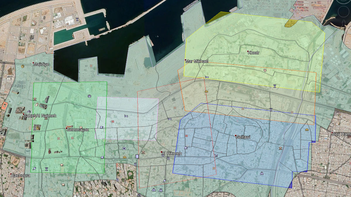
A total of 6 flights were carried out, gathering 4,304 images with a resolution of 20 MP. The pilots accumulated a total flight time of 4 hours, rendering a dataset of 35 GB. To use this information effectively, the team divided the data into 13 districts to match the layout of Beirut. These 13 data groups were carefully compiled, where the imagery from directly above the terrain was automatically added before being consolidated with imagery from the surroundings flights to include any overlap. The images were PPK corrected after the flight using eMotion, as this meant data with high absolute accuracy was used for processing and could be integrated into mapping survey results. Due to Pix4Dcloud being cloud-based Augment could share the data online rather than with large file transfers.
Augment set up a workflow that was efficient and effective, so it would not waste valuable recovery time:
- Establish the right team, gather the right expertise - Pix4D provided expertise about flight planning as well as appropriate processing software.
- Get permission from the local authorities - breaking regulations could mean the drone or data would be confiscated, or not allowed to be shared.
- Find the right hardware - a fixed-wing RTK drone provided better range and less need for GCPs on the ground
- Gather the data - double grid missions at a low altitude to have a clearer point cloud and capture the facades of buildings
- Processing with photogrammetry software - as the project was large, it was broken down into smaller chunks for processing in Pix4Dcloud
- Ensure an open data agreement with authorities
- Share the results with local NGOs, teaching them how to effectively use the collaborative tools of Pix4Dcloud
Working with Pix4Dcloud
Why was Pix4Dcloud the ideal product for this project? Firstly, as a cloud-based platform, Pix4Dcloud alleviates the need for powerful processing hardware from the user. As Augment was working in the field, with unpredictable conditions, this was a big help.
Additionally, Pix4Dcloud provides accurate results for users that can easily be measured and annotated online. This is ideal for sharing data where multiple organizations have an interest in the results. The annotations can highlight findings and comments for other teams, sharing information easily and online. The sharing settings can also be controlled - if Augment wanted to restrict access to the data they could do so, or make it open-access as they currently have. Not only that, but there are a range of outputs produced with Pix4Dcloud - a dense point cloud, 3D textured mesh, orthomosaic and DSM - that can be shared with relevant organizations and used for different purposes in the recovery process.
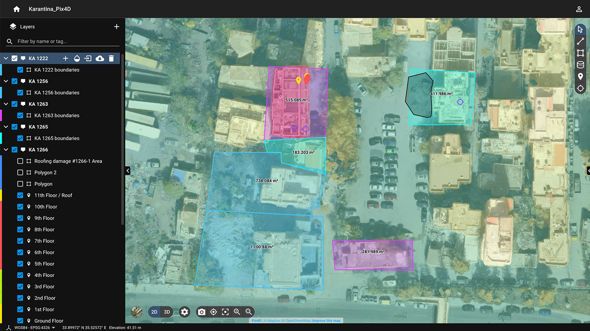
The software enables close analysis. Pix4Dcloud’s virtual inspector feature means that a user can click on a specific point when in 2D or 3D view. Clicking on the point shows the raw imagery captured for that point, which means Augment can study the specific details of that spot from multiple angles or viewpoints, whether it is road damage or a building facade.
Finally, Pix4Dcloud also has a timeline view, where previous maps can be uploaded and compared with the current damage using the 2D comparison. Further data collection can be processed and added to the project, so a clear progression of before, after, and recovery can be seen and on specific dates and times to track progress.
A team effort for drone disaster response
The team needed to get authorization to fly from the Lebanese Armed Forces’ Forward Emergency Room (FER). Drones are usually banned for civilian use in Beirut, but an exception was made for this mission. Once FER had provided the licenses, Augment could work with GeoSpatial Minds, who brought the fixed-wing drones and trained pilots for data collection. Live Love Beirut coordinated a training session for all involved and helped Augment network with other organizations, whilst Pix4D provided support and information about getting the best out of Pix4Dcloud.
The 4 hours of flights covered 2.88 km2 of land across the city. With support and training freely provided, the people on the ground quickly picked up how to turn their drone-collected data into 3D maps. Being protected from commercial usage, the 3D model and point cloud files were created under creative commons licenses.
By breaking down the map into the 13 smaller datasets, different areas of the city could easily be assigned to or shared with different NGOs working in the recovery effort via the Pix4Dcloud sharing link. This meant other organizations could access the data for the specific area or street they were looking at rather than locate it on a huge map.
Augment obtained an open data agreement from the Lebanese Armed Forces on behalf of the government. This was necessary because of the comprehensive nature of the data collected and the special authorization required to fly the drones.
Once the map was rendered on PIX4Dcloud, it was shared online with everyone. This way different teams could access it and work on emergency response.
Moving forward and using disaster maps
The range of applications for the map is wide and varied, both for immediate projects as well as future work. A few examples include:
- Blast modeling
- Emergency reconstruction
- Damage assessment (in Lebanon or remotely)
- Automated structural damage assessment
- Potential flood risk monitoring
- Urban planning
- Infrastructure impact and planning
- Multi actor coordination
- 3D layered information logging
- Viewpoint analysis and calculation of solar potential for roofs
Being protected from commercial usage, the 3D model and point cloud files were created under creative commons licenses. The multiplicity of uses of the model can’t be overestimated.
This successful use of photogrammetry, combined with the efforts of the organizations Augment worked with, has produced a meaningful resource that can be part of the immense task of moving Beirut forward after this catastrophe. Augment believes that in the coming months and years, their work can be helpful and play a part, however big or small, in Beirut’s recovery from the disaster.