PIX4Dcloud has georeferenced Gaussian splatting for drones
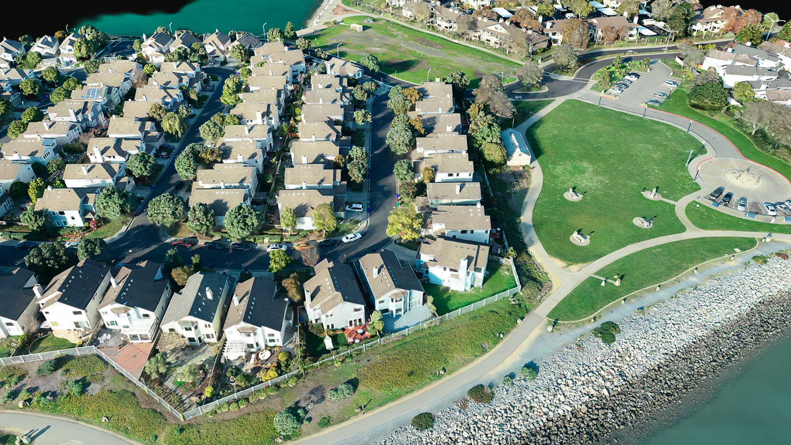
For years, construction professionals have relied on photogrammetry to bring the jobsite into the office. The vantage point came from drones, while the software delivered the 3D models. But anyone who has spent time navigating these datasets knows their limits, such as noise, blurred edges, and that thin structures like scaffolding, cables, or crane jibs often dissolve into artifacts. That is what makes the arrival of Gaussian splatting for drone datasets in PIX4Dcloud such a milestone. With visually stunning and georeferenced models, it’s a fundamental leap forward in how construction teams can capture, process, and share their projects.
Months ago, PIX4D introduced Gaussian splatting for terrestrial capture with PIX4Dcatch. Now, by extending it to drone imagery in PIX4Dcloud, we have enabled the efficient capture of large sites from a safe vantage point. By bringing Gaussian splatting into the core processing pipeline, PIX4D sets a new benchmark for the quality of point clouds and meshes.
Gaussian splatting for professionals
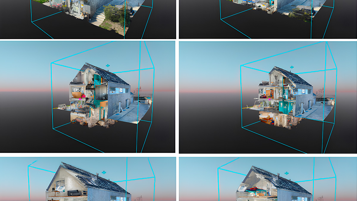
PIX4D merges Gaussian splatting with general photogrammetry into one common reconstruction workflow. Instead of splatting as an afterthought add-on, PIX4D incorporates splatting into the basic flow that controls the generation, verification, and georeferencing of point clouds and meshes.
Unlike traditional photogrammetry, instead of reducing the world into rigid meshes or disconnected points, Gaussian splatting constructs reality from millions of radiance-rich “splats". Each splat carries depth, color, and orientation, blending into a model that looks strikingly lifelike.
But realism alone is not enough. In construction, accuracy is non-negotiable. Without georeferencing, a model is just a picture. PIX4D’s implementation makes every dataset measurable by prioritizing geometric fidelity and by anchoring Gaussian splatting outputs to precise coordinate systems, providing trustworthy relative measurements within the model and absolute accuracy on site.
Georeferencing ensures that measurements are not approximations but reliable data points. It confirms that a slab is poured to the right height and in the right place, that a crane jib clears its designated safety margin, and that cubic meters of earth moved match the invoices submitted. It turns photorealistic imagery into accountable evidence.
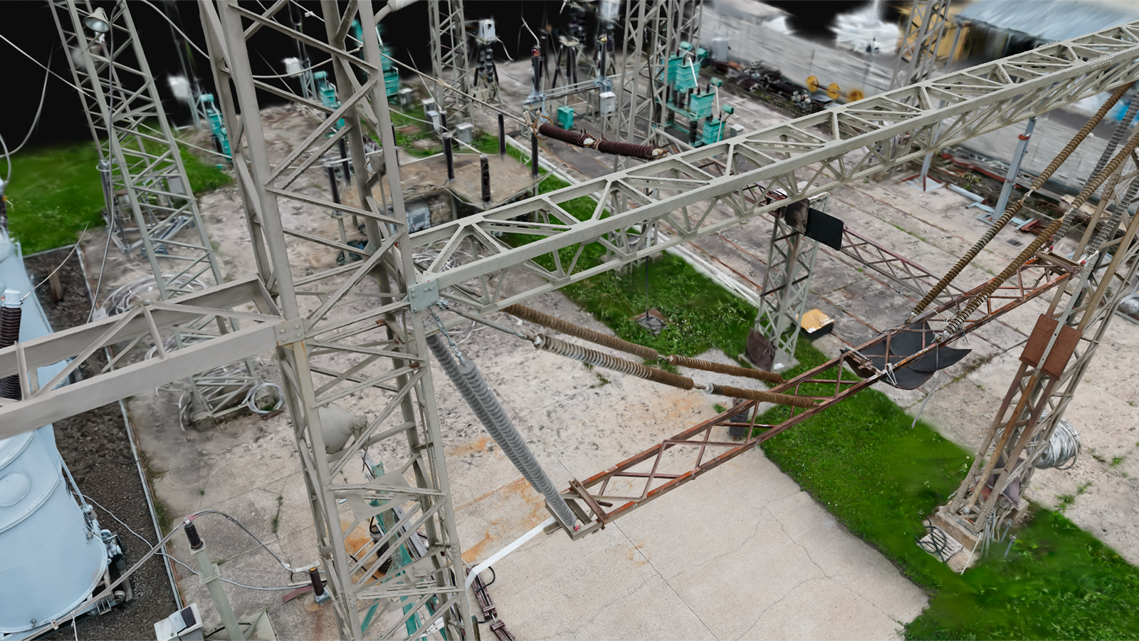
Most importantly, Gaussian splatting solves the Achilles heel of photogrammetry: the thin, complex structures that used to dissolve into noise. With Gaussian splatting, scaffolding pipes remain clear, crane jibs stand sharp against the skyline, and reinforcement grids are preserved instead of erased. The most demanding elements of construction sites become clearly visible and at the same time measurable.
Gaussian splatting enhanced point clouds
A key advantage of Gaussian splatting in PIX4Dcloud lies in the point clouds it produces.
Point clouds are the backbone of construction workflows. They are the raw data that surveyors, project managers, and contractors depend on. It is the underlying point cloud that makes the deliverables accurate. The point cloud and its outputs (2D maps and 3D meshes) answer the questions that drive every project: is the wall straight? Is the slab level? Has the right volume of material been placed? They form the evidence trail that underpins QA/QC, validates design against as-built, and often settles disputes.
Traditional photogrammetry has long delivered point clouds, but often with the drawback of noise, for example, floaters around cranes, wobbly edges along scaffolding, or gaps in reinforcement grids. Each artifact slows down the workflow, and hours can be spent cleaning data, second-guessing discrepancies, or repeating measurements.
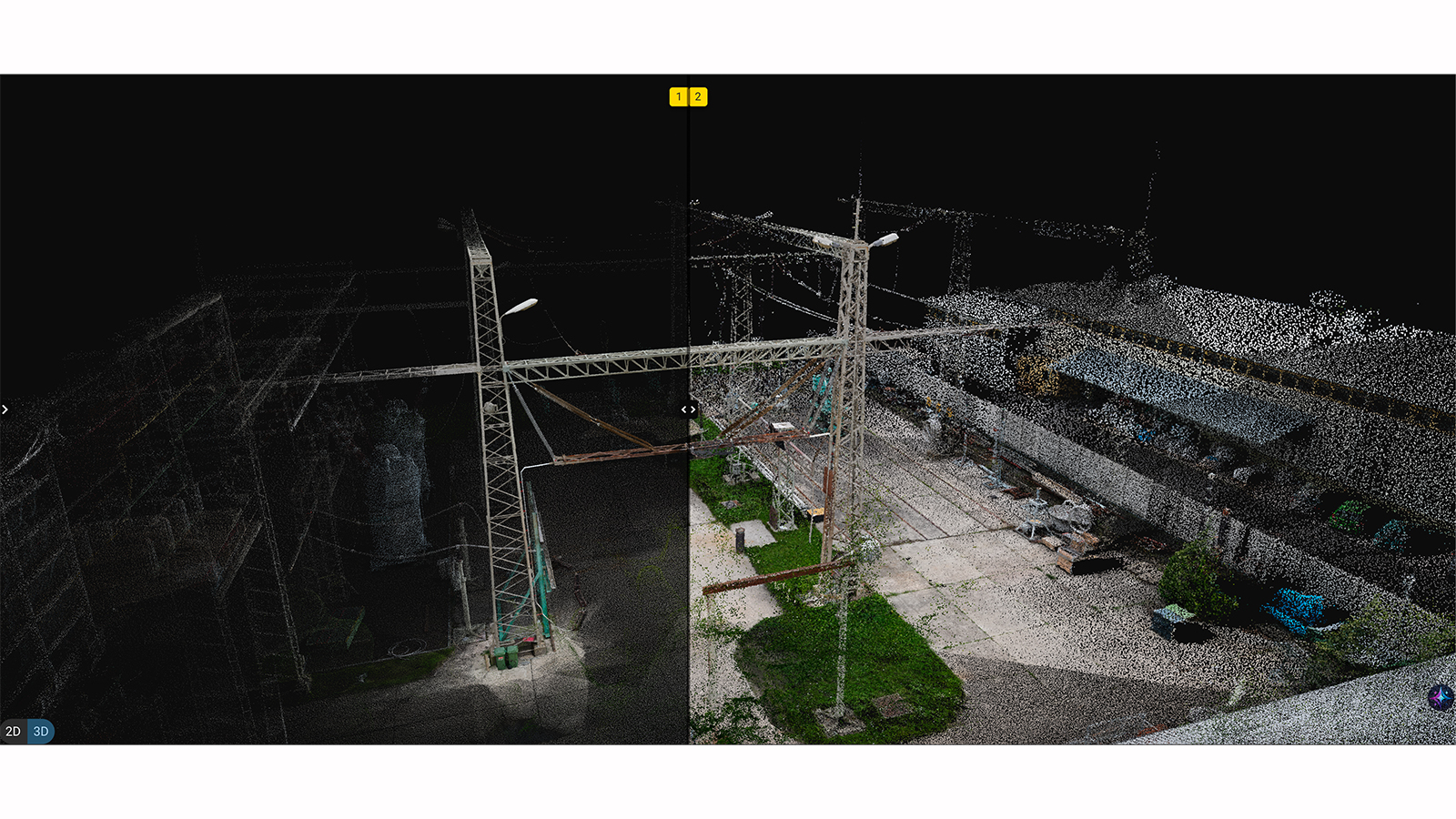
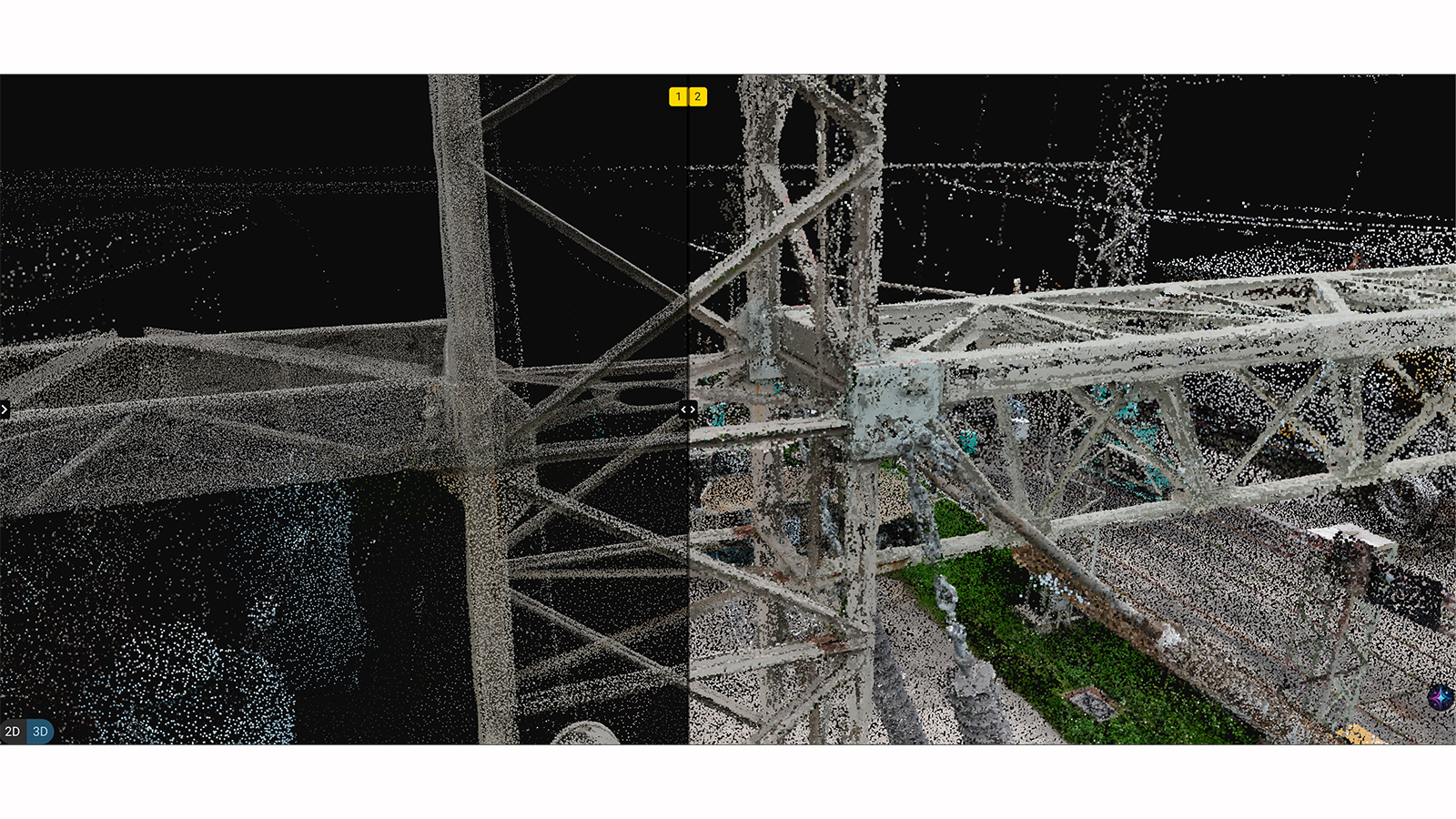
Gaussian splatting changes this baseline. By integrating splat intelligence into the reconstruction pipeline, PIX4Dcloud now delivers dramatically cleaner point clouds. Noise is reduced, surfaces are sharper, and thin structures retain their integrity. Early testers, many with years of experience fine-tuning desktop pipelines, reported surprise: the point clouds they received from the cloud were sharper and more reliable than what they could generate on high-end local machines.
Centralized and scalable team management
With the new “Organization Management”, PIX4Dcloud belongs to organizations, not individuals. Unlimited users can be added, scaling collaboration across entire companies. Role-based permissions ensure the right level of access — from editors to executives. The platform is designed for more than technical experts; it is built to serve the entire ecosystem of stakeholders who need access to reliable, measurable data.